Yarmouth Port
MA
12/08/2025 04:00 PM
26°F
TEMPERATURE
Winds 17 mph N
Mostly Sunny
Mostly sunny. High near 31, with temperatures falling to around 25 in the afternoon. North wind around 17 mph.
Alerts
You have (1) alert(s). Tap to see details.
| Small Craft Advisory issued December 8 at 12:46PM EST until December 8 at 6:00PM EST by NWS Boston/Norton MA | ||
| NWS Boston/Norton MA | ||
| Category | Certainty | Severity |
| Met | Likely | Minor |
| Status | Urgency | Category |
| Actual | Expected | Met |
| Effective | Ends | Expires |
| 12/08/2025 12:46 PM | 12/08/2025 06:00 PM | 12/08/2025 06:00 PM |
* WHAT...North winds 15 to 20 kt with gusts up to 25 kt and seas
3 to 5 feet.

* WHERE...In Massachusetts coastal waters, Cape Cod Bay and
Massachusetts Bay and Ipswich Bay. In Rhode Island coastal
waters, Rhode Island Sound and Block Island Sound.

* WHEN...Until 6 PM EST this evening.

* IMPACTS...Conditions will be hazardous to small craft.
|
||
Moonrise
08:24 PM
Moonset
10:35 AM
Sunrise
06:55 AM
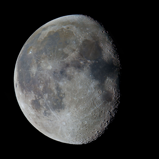
Moon Phase
Waning gibbous
Sunset
04:10 PM
Hourly Forecast
Mon, 04:00 PM
Mostly SunnyWinds: 17 mph N
26°
Mon, 05:00 PM
Mostly SunnyWinds: 16 mph N
25°
Mon, 06:00 PM
Mostly CloudyWinds: 14 mph N
23°
Mon, 07:00 PM
Mostly CloudyWinds: 13 mph N
23°
Mon, 08:00 PM
Mostly CloudyWinds: 12 mph N
23°
Mon, 09:00 PM
Mostly CloudyWinds: 12 mph N
21°
Mon, 10:00 PM
Mostly CloudyWinds: 10 mph N
20°
Mon, 11:00 PM
Mostly CloudyWinds: 10 mph N
20°
Tue, 12:00 AM
Partly CloudyWinds: 10 mph N
20°
Tue, 01:00 AM
Partly CloudyWinds: 10 mph N
20°
Tue, 02:00 AM
Partly CloudyWinds: 9 mph N
18°
Tue, 03:00 AM
Partly CloudyWinds: 9 mph NW
18°
Tue, 04:00 AM
Partly CloudyWinds: 8 mph NW
18°
Tue, 05:00 AM
Partly CloudyWinds: 7 mph NW
17°
Tue, 06:00 AM
SunnyWinds: 7 mph NW
17°
Tue, 07:00 AM
SunnyWinds: 6 mph NW
16°
Tue, 08:00 AM
SunnyWinds: 6 mph NW
18°
Tue, 09:00 AM
SunnyWinds: 6 mph W
20°
Tue, 10:00 AM
SunnyWinds: 6 mph W
22°
Tue, 11:00 AM
SunnyWinds: 7 mph W
23°
Tue, 12:00 PM
SunnyWinds: 7 mph SW
24°
Tue, 01:00 PM
SunnyWinds: 8 mph SW
24°
Tue, 02:00 PM
SunnyWinds: 8 mph SW
26°
Tue, 03:00 PM
Mostly SunnyWinds: 9 mph SW
26°
Winds: 17 mph N
Mostly sunny. High near 31, with temperatures falling to around 25 in the afternoon. North wind around 17 mph.
Winds: 7 to 14 mph NW
Partly cloudy, with a low around 15. Northwest wind 7 to 14 mph.
Winds: 6 to 10 mph W
Sunny. High near 36, with temperatures falling to around 24 in the afternoon. West wind 6 to 10 mph.
Winds: 12 to 16 mph SW
A slight chance of snow between 9pm and 10pm, then a chance of rain. Mostly cloudy, with a low around 32. Southwest wind 12 to 16 mph, with gusts as high as 28 mph. Chance of precipitation is 50%.
Winds: 13 to 17 mph SW
A chance of rain. Mostly cloudy, with a high near 50. Southwest wind 13 to 17 mph. Chance of precipitation is 50%.
Winds: 13 to 16 mph SW
A chance of rain. Mostly cloudy, with a low around 36. Southwest wind 13 to 16 mph. Chance of precipitation is 50%.
Winds: 16 mph W
A slight chance of rain before 11am. Mostly sunny, with a high near 44. West wind around 16 mph.
Winds: 15 mph W
Partly cloudy, with a low around 26. West wind around 15 mph.
Winds: 15 mph W
A slight chance of snow after 9am. Mostly sunny, with a high near 36. West wind around 15 mph.
Winds: 12 mph W
A chance of snow. Mostly cloudy, with a low around 28. West wind around 12 mph. Chance of precipitation is 40%.
Winds: 10 to 15 mph W
A chance of snow before 8am, then a chance of rain and snow. Partly sunny, with a high near 39. West wind 10 to 15 mph. Chance of precipitation is 40%.
Winds: 15 mph W
A chance of snow. Mostly cloudy, with a low around 23. West wind around 15 mph. Chance of precipitation is 40%.
Winds: 15 mph W
A slight chance of snow. Mostly sunny, with a high near 34. West wind around 15 mph.
Winds: 15 mph NW
A slight chance of snow before 1am. Partly cloudy, with a low around 21. Northwest wind around 15 mph.
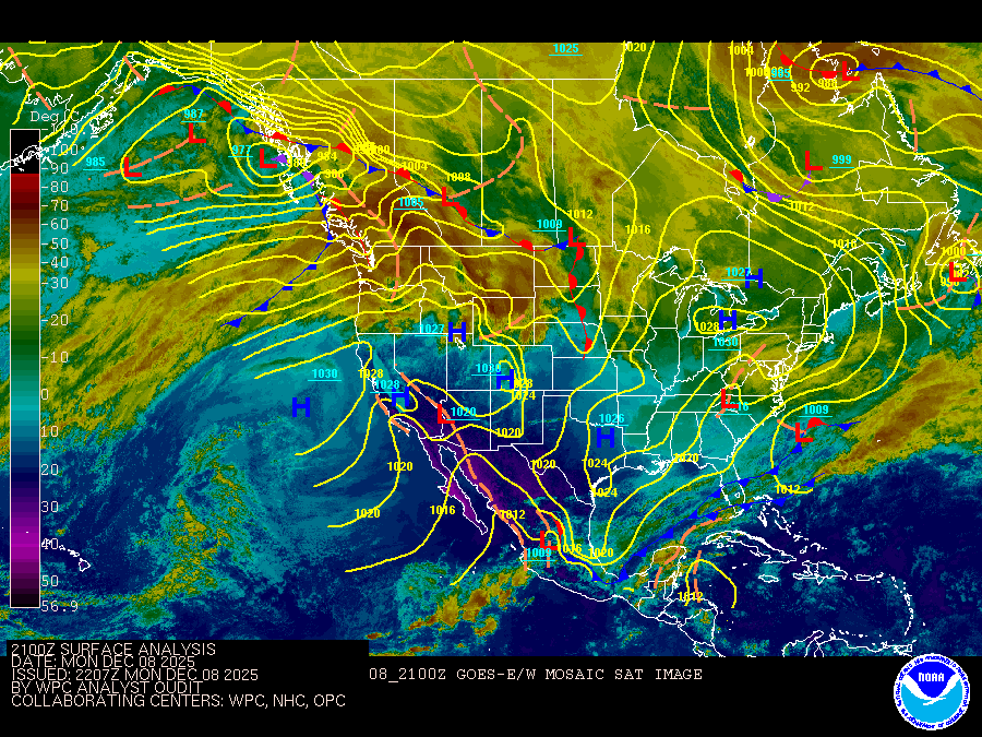
Coastal Waters Forecast for Massachusetts and Rhode Island
National Weather Service Boston/Norton MA
for Massachusetts and Rhode Island coastal waters. High pres builds into the waters through Tue. It then moves east as low pres moves over the waters later Wed into early Thurs. High pres then briefly returns Thurs before becming more unsettled again for Fri and Sat.
Coastal waters from the Merrimack River MA to Watch Hill RI out to 25 NM
SMALL CRAFT ADVISORY IN EFFECT UNTIL 4 AM EST TUESDAY
SMALL CRAFT ADVISORY IN EFFECT UNTIL 6 PM EST THIS EVENING
SMALL CRAFT ADVISORY IN EFFECT UNTIL 6 PM EST THIS EVENING
SMALL CRAFT ADVISORY IN EFFECT UNTIL 4 AM EST TUESDAY
SMALL CRAFT ADVISORY IN EFFECT UNTIL 4 AM EST TUESDAY
SMALL CRAFT ADVISORY IN EFFECT UNTIL 4 AM EST TUESDAY
TONIGHT
N winds 15 to 20 kt, diminishing to 10 to 15 kt after midnight Seas 2 to 3 ft Wave Detail: N 3 ft at 4 seconds and E 1 foot at 9 seconds
TUE
NW winds 5 to 10 kt, becoming SW 10 to 15 kt in the afternoon Seas around 2 ft Wave Detail: N 1 foot at 4 seconds and E 1 foot at 9 seconds
TUE NIGHT
SW winds 20 to 25 kt with gusts up to 35 kt Seas 3 to 5 ft Wave Detail: SW 4 ft at 5 seconds and NE 1 foot at 5 seconds A chance of rain
WED
SW winds 15 to 20 kt, increasing to 20 to 25 kt in the afternoon Gusts up to 30 kt Seas 4 to 6 ft Wave Detail: SW 5 ft at 7 seconds and SW 3 ft at 4 seconds A chance of rain in the afternoon
WED NIGHT
SW winds 20 to 25 kt with gusts up to 30 kt Seas 5 to 7 ft Wave Detail: SW 5 ft at 7 seconds and W 4 ft at 4 seconds A chance of rain
THU
W winds 20 to 25 kt Seas 4 to 6 ft Wave Detail: W 4 ft at 4 seconds and SW 3 ft at 9 seconds
THU NIGHT
W winds 20 to 25 kt Seas 3 to 5 ft
FRI
W winds 20 to 25 kt Seas 3 to 4 ft
FRI NIGHT
W winds 15 to 20 kt Seas 2 to 4 ft A chance of rain
SAT
W winds 20 to 25 kt Seas 3 to 5 ft A chance of rain and snow
SAT NIGHT
W winds 20 to 25 kt with gusts up to 30 kt Seas 4 to 6 ft A chance of snow and rain
TONIGHT
N winds 10 to 15 kt Gusts up to 20 kt this evening Seas around 2 ft Wave Detail: N 2 ft at 4 seconds and SW 1 foot at 6 seconds
TUE
NW winds 5 to 10 kt, becoming SW 10 to 15 kt in the afternoon Seas 1 foot or less, then around 2 ft in the afternoon Wave Detail: N 1 foot at 3 seconds and SE 1 foot at 9 seconds, becoming SW 1 foot at 2 seconds and NE 1 foot at 4 seconds
TUE NIGHT
SW winds 20 to 25 kt with gusts up to 35 kt Seas 4 to 6 ft Wave Detail: SW 6 ft at 7 seconds and SW 2 ft at 4 seconds A chance of rain
WED
SW winds 20 to 25 kt, increasing to 25 to 30 kt in the afternoon Seas 5 to 7 ft Wave Detail: SW 7 ft at 7 seconds and W 1 foot at 4 seconds A chance of rain in the afternoon
WED NIGHT
SW winds 25 to 30 kt, becoming W 20 to 25 kt after midnight Seas 6 to 9 ft Wave Detail: SW 8 ft at 8 seconds and SW 2 ft at 4 seconds A chance of rain
THU
W winds 20 to 25 kt Seas 5 to 7 ft Wave Detail: SW 7 ft at 9 seconds and W 2 ft at 4 seconds
THU NIGHT
W winds 20 to 25 kt Seas 3 to 5 ft
FRI
W winds 20 to 25 kt Seas 3 to 4 ft
FRI NIGHT
W winds 15 to 20 kt Seas 2 to 4 ft A chance of snow and rain
SAT
W winds 20 to 25 kt Seas 3 to 5 ft A chance of rain and snow
SAT NIGHT
W winds 20 to 25 kt Seas 4 to 6 ft A chance of snow
TONIGHT
N winds 10 to 15 kt with gusts up to 20 kt, diminishing to 5 to 10 kt after midnight Seas around 2 ft Wave Detail: N 2 ft at 4 seconds and E 1 foot at 8 seconds
TUE
NW winds 5 to 10 kt, becoming SW 10 to 15 kt with gusts up to 20 kt in the afternoon Seas 1 foot or less, then around 2 ft in the afternoon Wave Detail: N 1 foot at 3 seconds and E 1 foot at 9 seconds, becoming SW 1 foot at 2 seconds and NE 1 foot at 4 seconds
TUE NIGHT
SW winds 20 to 25 kt with gusts up to 30 kt Seas 3 to 5 ft Wave Detail: SW 5 ft at 5 seconds and NE 1 foot at 5 seconds A chance of rain
WED
SW winds 15 to 20 kt, increasing to 25 to 30 kt in the afternoon Seas 4 to 6 ft Wave Detail: SW 6 ft at 7 seconds and W 2 ft at 4 seconds A chance of rain in the afternoon
WED NIGHT
SW winds 25 to 30 kt, becoming W 20 to 25 kt after midnight Seas 4 to 6 ft Wave Detail: SW 6 ft at 8 seconds and SW 2 ft at 4 seconds A chance of rain
THU
W winds 15 to 20 kt with gusts up to 25 kt Seas 4 to 6 ft, subsiding to 3 to 4 ft in the afternoon Wave Detail: SW 5 ft at 9 seconds and W 2 ft at 4 seconds, becoming SW 4 ft at 9 seconds and W 3 ft at 4 seconds
THU NIGHT
W winds 15 to 20 kt with gusts up to 25 kt Seas 3 to 4 ft
FRI
W winds 15 to 20 kt with gusts up to 25 kt Seas 2 to 3 ft
FRI NIGHT AND SAT
W winds 10 to 15 kt, increasing to 15 to 20 kt Gusts up to 25 kt Seas 2 to 4 ft A chance of snow and rain
SAT NIGHT
W winds 20 to 25 kt Seas 3 to 4 ft A chance of snow
SMALL CRAFT ADVISORY IN EFFECT UNTIL 6 PM EST THIS EVENING
SMALL CRAFT ADVISORY IN EFFECT UNTIL 6 PM EST THIS EVENING
TONIGHT
NW winds 10 to 15 kt, diminishing to 5 to 10 kt after midnight Waves around 2 ft this evening, then 1 foot or less
TUE
W winds 5 to 10 kt, becoming SW 10 to 15 kt in the afternoon Waves 1 foot or less, then around 2 ft in the afternoon
TUE NIGHT
SW winds 10 to 15 kt with gusts up to 20 kt Waves around 2 ft A chance of snow in the evening, then a chance of rain after midnight
WED
SW winds 10 to 15 kt, becoming S 15 to 20 kt in the afternoon Gusts up to 25 kt Waves around 2 ft A chance of rain in the morning, then rain likely in the afternoon
WED NIGHT
SW winds 15 to 20 kt with gusts up to 25 kt Waves around 2 ft Rain likely, mainly in the evening
THU AND THU NIGHT
W winds 15 to 20 kt with gusts up to 25 kt Waves around 2 ft
FRI
W winds 15 to 20 kt with gusts up to 25 kt Waves around 2 ft
FRI NIGHT AND SAT
W winds 10 to 15 kt, increasing to 15 to 20 kt Waves around 2 ft A chance of snow
SAT NIGHT
W winds 15 to 20 kt Waves around 2 ft
TONIGHT
N winds 10 to 15 kt, diminishing to 5 to 10 kt after midnight Waves around 2 ft
TUE
NW winds around 5 kt, becoming SW in the afternoon Waves 1 foot or less, then around 2 ft in the afternoon
TUE NIGHT
SW winds 15 to 20 kt with gusts up to 30 kt Waves 2 to 4 ft A chance of rain
WED
SW winds 15 to 20 kt, increasing to 20 to 25 kt in the afternoon Gusts up to 30 kt Waves 2 to 4 ft, building to 4 to 6 ft in the afternoon A chance of rain in the afternoon
WED NIGHT
SW winds 20 to 25 kt, becoming W 15 to 20 kt after midnight Gusts up to 30 kt Waves 3 to 5 ft A chance of rain
THU
W winds 15 to 20 kt with gusts up to 25 kt Waves 3 to 5 ft, subsiding to 2 to 3 ft in the afternoon
THU NIGHT
W winds 15 to 20 kt, diminishing to 10 to 15 kt after midnight Waves 2 to 3 ft
FRI
W winds 10 to 15 kt with gusts up to 20 kt Waves 2 to 3 ft
FRI NIGHT
W winds 10 to 15 kt Waves 2 to 3 ft A chance of snow
SAT
W winds 15 to 20 kt Waves 2 to 3 ft A chance of snow and rain
SAT NIGHT
W winds 15 to 20 kt Waves 2 to 3 ft A chance of snow
Oilrig
NWS
Buoy
Fixed Station
USGS
Ship
Other

Search Results
