Nuangola
PA
12/08/2025 12:00 AM
28°F
TEMPERATURE
Winds 7 mph NW
Mostly Cloudy
Partly cloudy, with a low around 17. Northwest wind around 8 mph, with gusts as high as 21 mph.
Moonrise
07:28 PM
Moonset
10:12 AM
Sunrise
07:15 AM
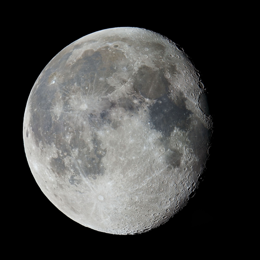
Moon Phase
Waning gibbous
Sunset
04:35 PM
Hourly Forecast
Mon, 12:00 AM
Mostly CloudyWinds: 7 mph NW
28°
Mon, 01:00 AM
Partly CloudyWinds: 7 mph NW
26°
Mon, 02:00 AM
Partly CloudyWinds: 7 mph NW
24°
Mon, 03:00 AM
Partly CloudyWinds: 8 mph NW
23°
Mon, 04:00 AM
Partly CloudyWinds: 7 mph NW
22°
Mon, 05:00 AM
Partly CloudyWinds: 8 mph NW
19°
Mon, 06:00 AM
Mostly SunnyWinds: 8 mph N
19°
Mon, 07:00 AM
Mostly SunnyWinds: 8 mph N
18°
Mon, 08:00 AM
Mostly SunnyWinds: 8 mph N
17°
Mon, 09:00 AM
Mostly SunnyWinds: 8 mph N
19°
Mon, 10:00 AM
Mostly SunnyWinds: 8 mph N
20°
Mon, 11:00 AM
Mostly SunnyWinds: 8 mph N
21°
Mon, 12:00 PM
Mostly SunnyWinds: 8 mph N
22°
Mon, 01:00 PM
Partly SunnyWinds: 7 mph N
23°
Mon, 02:00 PM
Partly SunnyWinds: 5 mph N
23°
Mon, 03:00 PM
Partly SunnyWinds: 3 mph N
24°
Mon, 04:00 PM
Partly SunnyWinds: 2 mph N
22°
Mon, 05:00 PM
Partly SunnyWinds: 2 mph N
20°
Mon, 06:00 PM
Mostly CloudyWinds: 1 mph N
18°
Mon, 07:00 PM
Mostly CloudyWinds: 1 mph NE
15°
Mon, 08:00 PM
Partly CloudyWinds: 1 mph N
14°
Mon, 09:00 PM
Partly CloudyWinds: 1 mph N
13°
Mon, 10:00 PM
Partly CloudyWinds: 0 mph
12°
Mon, 11:00 PM
Partly CloudyWinds: 0 mph
11°
Winds: 8 mph NW
Partly cloudy, with a low around 17. Northwest wind around 8 mph, with gusts as high as 21 mph.
Winds: 2 to 8 mph N
Mostly sunny, with a high near 24. North wind 2 to 8 mph, with gusts as high as 22 mph.
Winds: 1 mph NE
Partly cloudy, with a low around 6. Northeast wind around 1 mph.
Winds: 1 to 7 mph S
Partly sunny, with a high near 30. South wind 1 to 7 mph, with gusts as high as 22 mph.
Winds: 7 mph S
A slight chance of snow after 1am. Cloudy, with a low around 25. South wind around 7 mph, with gusts as high as 22 mph. Chance of precipitation is 20%.
Winds: 7 mph S
A slight chance of snow before 7am, then rain and snow likely. Cloudy, with a high near 41. Chance of precipitation is 70%. New snow accumulation of less than half an inch possible.
Winds: 6 mph W
Rain likely before 1am. Mostly cloudy, with a low around 28. Chance of precipitation is 70%.
Winds: 6 mph W
Partly sunny, with a high near 35.
Winds: 3 mph W
A chance of snow showers after 7pm. Mostly cloudy, with a low around 22. Chance of precipitation is 30%.
Winds: 6 mph W
A chance of snow showers. Partly sunny, with a high near 31. Chance of precipitation is 30%.
Winds: 6 mph W
A chance of snow showers. Mostly cloudy, with a low around 17. Chance of precipitation is 30%.
Winds: 8 mph W
A slight chance of snow showers. Mostly cloudy, with a high near 27.
Winds: 7 mph W
A slight chance of snow showers before 7pm. Mostly cloudy, with a low around 15.
Winds: 7 mph W
Partly sunny, with a high near 26.
Coastal Waters Forecast for New Jersey and Delaware
National Weather Service Mount Holly NJ
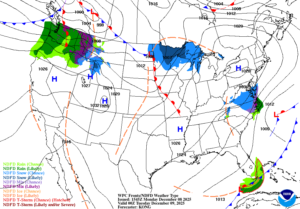
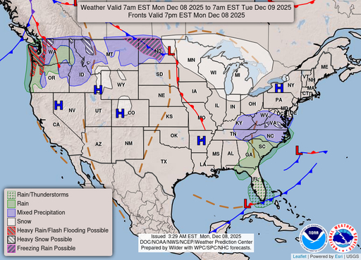
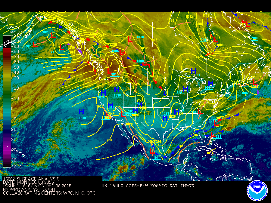
FOR THE COASTAL WATERS FROM SANDY HOOK NJ TO FENWICK ISLAND DE AND FOR DELAWARE BAY. A cold front will cross the region and move offshore overnight, ushering in arctic high pressure with much colder and drier conditions through Tuesday. A quick moving low pressure system and its associated fronts will impact the region on Wednesday, then a clipper system will impact the area Thursday night into Friday. Arctic high pressure will then return into next weekend, resulting in a prolonged period of well below normal temperatures.
Sandy Hook NJ to Fenwick Island DE to 20 NM offshore and Delaware Bay
SMALL CRAFT ADVISORY IN EFFECT FROM 1 AM EST MONDAY THROUGH MONDAY AFTERNOON
SMALL CRAFT ADVISORY IN EFFECT FROM 1 AM EST MONDAY THROUGH LATE MONDAY NIGHT
SMALL CRAFT ADVISORY IN EFFECT FROM 1 AM EST MONDAY THROUGH LATE MONDAY NIGHT
SMALL CRAFT ADVISORY IN EFFECT FROM 1 AM EST MONDAY THROUGH LATE MONDAY NIGHT
SMALL CRAFT ADVISORY IN EFFECT FROM 1 AM EST MONDAY THROUGH LATE MONDAY NIGHT
SMALL CRAFT ADVISORY IN EFFECT FROM 1 AM EST MONDAY THROUGH LATE MONDAY NIGHT
SMALL CRAFT ADVISORY IN EFFECT FROM 1 AM EST MONDAY THROUGH MONDAY AFTERNOON
SMALL CRAFT ADVISORY IN EFFECT FROM 1 AM EST MONDAY THROUGH MONDAY AFTERNOON
Oilrig
NWS
Buoy
Fixed Station
USGS
Ship
Other
Search Results
