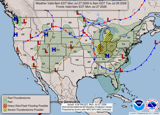
Hampton
VA
12/07/2025 02:00 AM
35°F
TEMPERATURE
Winds 2 mph NW
Partly Cloudy
Widespread fog after 3am. Partly cloudy, with a low around 33. Northwest wind around 2 mph.
Alerts
You have (1) alert(s). Tap to see details.
| Dense Fog Advisory issued December 7 at 12:53AM EST until December 7 at 9:00AM EST by NWS Wakefield VA | ||
| NWS Wakefield VA | ||
| Category | Certainty | Severity |
| Met | Likely | Moderate |
| Status | Urgency | Category |
| Actual | Expected | Met |
| Effective | Ends | Expires |
| 12/07/2025 12:53 AM | 12/07/2025 09:00 AM | 12/07/2025 09:00 AM |
* WHAT...Visibility one quarter to one half mile or less in dense
fog.
* WHERE...Northampton, Hampton/Poquoson, and Norfolk/Portsmouth
Counties, and Virginia Beach.
* WHEN...Until 9 AM EST this morning.
* IMPACTS...Low visibility could make driving conditions hazardous.
|
||
Moonrise
06:33 PM
Moonset
09:11 AM
Sunrise
07:04 AM
Moon Phase
Waning gibbous
Sunset
04:48 PM
Hourly Forecast
Sun, 02:00 AM
Partly CloudyWinds: 2 mph NW
35°
Sun, 03:00 AM
Patchy FogWinds: 2 mph N
35°
Sun, 04:00 AM
Areas Of FogWinds: 2 mph N
34°
Sun, 05:00 AM
Widespread FogWinds: 2 mph N
34°
Sun, 06:00 AM
Widespread FogWinds: 2 mph N
34°
Sun, 07:00 AM
Widespread FogWinds: 3 mph N
34°
Sun, 08:00 AM
Widespread FogWinds: 3 mph N
36°
Sun, 09:00 AM
Areas Of FogWinds: 3 mph N
37°
Sun, 10:00 AM
Partly SunnyWinds: 3 mph N
39°
Sun, 11:00 AM
Partly SunnyWinds: 3 mph NE
41°
Sun, 12:00 PM
Partly SunnyWinds: 5 mph S
42°
Sun, 01:00 PM
Partly SunnyWinds: 5 mph S
44°
Sun, 02:00 PM
Mostly SunnyWinds: 5 mph S
45°
Sun, 03:00 PM
Partly SunnyWinds: 5 mph S
45°
Sun, 04:00 PM
Partly SunnyWinds: 3 mph SW
46°
Sun, 05:00 PM
Partly SunnyWinds: 2 mph W
45°
Sun, 06:00 PM
Mostly CloudyWinds: 2 mph NW
43°
Sun, 07:00 PM
Mostly CloudyWinds: 2 mph W
42°
Sun, 08:00 PM
Mostly CloudyWinds: 2 mph NW
41°
Sun, 09:00 PM
Mostly CloudyWinds: 2 mph NW
41°
Sun, 10:00 PM
Mostly CloudyWinds: 2 mph NW
40°
Sun, 11:00 PM
Mostly CloudyWinds: 3 mph NW
40°
Mon, 12:00 AM
Mostly CloudyWinds: 3 mph NW
40°
Mon, 01:00 AM
Mostly CloudyWinds: 5 mph N
40°
Winds: 2 mph NW
Widespread fog after 3am. Partly cloudy, with a low around 33. Northwest wind around 2 mph.
Winds: 5 mph NW
Widespread fog before 10am. Partly sunny, with a high near 47. Northwest wind around 5 mph.
Winds: 2 to 17 mph NW
Mostly cloudy, with a low around 38. Northwest wind 2 to 17 mph.
Winds: 20 to 24 mph N
Rain likely before 10am, then rain and snow likely. Cloudy, with a high near 40. North wind 20 to 24 mph, with gusts as high as 36 mph. Chance of precipitation is 60%. New snow accumulation of less than half an inch possible.
Winds: 8 to 22 mph N
A chance of rain and snow before 7pm. Mostly cloudy, with a low around 29. North wind 8 to 22 mph, with gusts as high as 30 mph. Chance of precipitation is 50%. New snow accumulation of less than half an inch possible.
Winds: 7 mph NW
Sunny, with a high near 43.
Winds: 6 to 10 mph SW
Partly cloudy, with a low around 34.
Winds: 10 to 15 mph SW
Partly sunny, with a high near 54.
Winds: 9 to 14 mph SW
Mostly cloudy, with a low around 40.
Winds: 7 to 10 mph W
Partly sunny, with a high near 52.
Winds: 8 mph S
A chance of rain after 7pm. Mostly cloudy, with a low around 40. Chance of precipitation is 40%.
Winds: 8 to 12 mph NW
A chance of rain. Mostly cloudy, with a high near 50. Chance of precipitation is 50%.
Winds: 12 mph NW
A chance of rain before 1am, then a chance of rain and snow. Mostly cloudy, with a low around 29. Chance of precipitation is 40%.
Winds: 14 mph NW
A chance of rain and snow before 7am. Mostly sunny, with a high near 40.
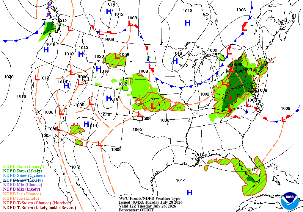
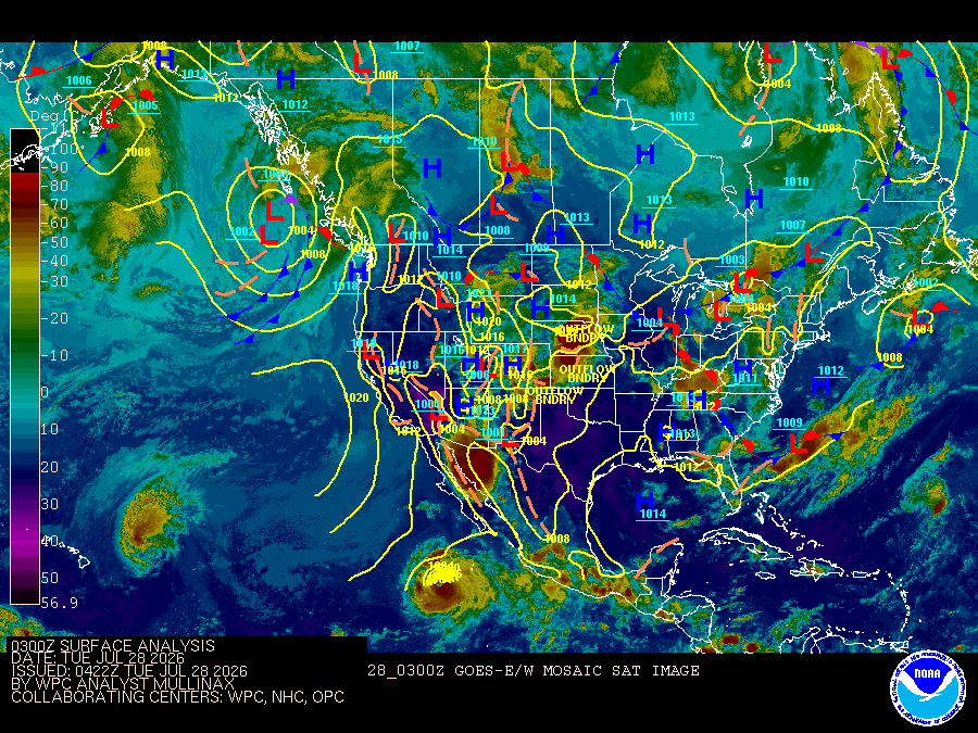
Coastal Waters Forecast for Virginia
National Weather Service Wakefield VA
for Fenwick Island DE to Currituck Beach Light NC out 20 nautical miles including Virginia portion of the Chesapeake Bay, Currituck Sound and portions of the James, York, and Rappahannock Rivers.
Virginia Portion of the Chesapeake Bay, Currituck Sound and Atlantic Coastal Waters from Fenwick Island DE to Currituck Beach Light NC out 20 nautical miles High pressure builds to the west through tonight, as weak low pressure slides well south of the local waters. Degraded marine conditions return Monday morning, as a strong cold front drops across the area.
DENSE FOG ADVISORY IN EFFECT UNTIL 9 AM EST THIS MORNING
REST OF TONIGHT
NW winds 10 to 15 kt Seas around 3 ft Wave Detail: E 3 ft at 9 seconds and S 1 foot at 6 seconds
SUN
NW winds 5 to 10 kt with gusts up to 15 kt, becoming SW late Seas 2 to 3 ft Wave Detail: E 3 ft at 9 seconds and S 1 foot at 6 seconds
SUN NIGHT
W winds 5 to 10 kt with gusts up to 15 kt, becoming NW 15 to 20 kt with gusts up to 30 kt after midnight Seas around 2 ft, building to 3 to 4 ft, occasionally to 6 ft after midnight Wave Detail: SE 2 ft at 7 seconds, becoming NW 2 ft at 3 seconds and E 2 ft at 9 seconds
MON
N winds 20 to 25 kt with gusts up to 30 kt Seas 6 to 7 ft, occasionally to 10 ft Wave Detail: NE 6 ft at 6 seconds and N 3 ft at 3 seconds
MON NIGHT
NE winds 20 to 25 kt, becoming N 15 to 20 kt after midnight Gusts up to 30 kt Seas 6 to 7 ft, occasionally to 10 ft Wave Detail: NE 6 ft at 7 seconds
TUE
N winds 5 to 10 kt, becoming SW 10 to 15 kt with gusts up to 20 kt in the afternoon Seas 4 to 5 ft, occasionally to 7 ft Wave Detail: NE 4 ft at 7 seconds and SE 1 foot at 9 seconds
TUE NIGHT
SW winds 15 to 20 kt with gusts up to 30 kt Seas 4 to 5 ft, occasionally to 7 ft
WED
SW winds 20 to 25 kt with gusts up to 35 kt Seas 5 to 6 ft, occasionally to 9 ft
WED NIGHT
W winds 20 to 25 kt with gusts up to 35 kt Seas 5 to 6 ft, occasionally to 9 ft
THU
W winds 15 to 20 kt with gusts up to 25 kt Seas 4 to 5 ft, occasionally to 7 ft
THU NIGHT
W winds 15 to 20 kt Seas around 3 ft, building to 4 to 5 ft, occasionally to 7 ft after midnight A chance of rain after midnight
REST OF TONIGHT
NW winds 10 to 15 kt, becoming N 5 to 10 kt late Seas around 3 ft Wave Detail: E 3 ft at 9 seconds and S 1 foot at 6 seconds
SUN
NW winds 5 to 10 kt with gusts up to 15 kt, becoming SW late Seas 2 to 3 ft Wave Detail: E 3 ft at 9 seconds and S 1 foot at 6 seconds
SUN NIGHT
SW winds 5 to 10 kt, becoming N 15 to 20 kt with gusts up to 30 kt after midnight Seas around 2 ft, building to 3 to 4 ft, occasionally to 6 ft after midnight Wave Detail: SE 2 ft at 7 seconds, becoming N 2 ft at 2 seconds and E 2 ft at 9 seconds
MON
N winds 20 to 25 kt, increasing to 25 to 30 kt in the afternoon Gusts up to 35 kt Seas 4 to 5 ft, occasionally to 7 ft, building to 6 to 7 ft, occasionally to 10 ft in the afternoon Wave Detail: NE 5 ft at 5 seconds and E 2 ft at 9 seconds, becoming NE 6 ft at 6 seconds and E 1 foot at 9 seconds A chance of rain in the afternoon
MON NIGHT
NE winds 20 to 25 kt with gusts up to 35 kt, becoming N 15 to 20 kt with gusts up to 25 kt after midnight Seas 6 to 8 ft, occasionally to 12 ft, subsiding to 5 to 6 ft, occasionally to 9 ft after midnight Wave Detail: NE 7 ft at 7 seconds, becoming NE 6 ft at 8 seconds
TUE
N winds 5 to 10 kt, becoming SW 10 to 15 kt in the afternoon Gusts up to 20 kt Seas 4 to 5 ft, occasionally to 7 ft Wave Detail: NE 5 ft at 7 seconds
TUE NIGHT
SW winds 15 to 20 kt, increasing to 20 to 25 kt after midnight Gusts up to 30 kt Seas 4 to 5 ft, occasionally to 7 ft
WED
SW winds 20 to 25 kt with gusts up to 35 kt Seas 5 to 6 ft, occasionally to 9 ft
WED NIGHT
SW winds 20 to 25 kt with gusts up to 35 kt Seas 5 to 6 ft, occasionally to 9 ft
THU
W winds 15 to 20 kt with gusts up to 30 kt Seas 4 to 5 ft, occasionally to 7 ft
THU NIGHT
SW winds 15 to 20 kt Seas around 3 ft, building to 4 to 5 ft, occasionally to 7 ft after midnight A chance of rain after midnight
REST OF TONIGHT
N winds 5 to 10 kt with gusts up to 15 kt Seas 2 to 3 ft Wave Detail: SE 3 ft at 7 seconds
SUN
N winds 5 to 10 kt, becoming NW early in the afternoon, then becoming SW late Seas 2 to 3 ft Wave Detail: SE 3 ft at 7 seconds
SUN NIGHT
SW winds 5 to 10 kt, becoming N 15 to 20 kt with gusts up to 25 kt after midnight Seas 2 to 3 ft Wave Detail: E 2 ft at 8 seconds and NE 1 foot at 2 seconds
MON
N winds 20 to 25 kt, increasing to 25 to 30 kt in the afternoon Gusts up to 35 kt Seas 4 to 5 ft, occasionally to 7 ft, building to 6 to 7 ft, occasionally to 10 ft in the afternoon Wave Detail: NE 5 ft at 5 seconds and E 2 ft at 9 seconds, becoming NE 6 ft at 6 seconds and E 1 foot at 9 seconds A chance of rain and snow in the afternoon
MON NIGHT
N winds 25 to 30 kt with gusts up to 35 kt, diminishing to 15 to 20 kt with gusts up to 25 kt after midnight Seas 5 to 6 ft, occasionally to 9 ft Wave Detail: NE 6 ft at 8 seconds
TUE
N winds 5 to 10 kt, becoming W in the afternoon Gusts up to 15 kt Seas 4 to 5 ft, occasionally to 7 ft Wave Detail: NE 5 ft at 8 seconds and E 1 foot at 8 seconds
TUE NIGHT
SW winds 10 to 15 kt, increasing to 15 to 20 kt after midnight Gusts up to 25 kt Seas 3 to 4 ft, occasionally to 6 ft
WED
SW winds 20 to 25 kt with gusts up to 35 kt Seas 4 to 5 ft, occasionally to 7 ft
WED NIGHT
W winds 20 to 25 kt with gusts up to 30 kt Seas 4 to 5 ft, occasionally to 7 ft
THU
W winds 15 to 20 kt with gusts up to 25 kt Seas 3 to 4 ft, occasionally to 6 ft
THU NIGHT
SW winds 15 kt with gusts up to 20 kt Seas 3 to 4 ft, occasionally to 6 ft A chance of rain after midnight
REST OF TONIGHT
N winds 5 to 10 kt with gusts up to 15 kt Seas around 3 ft Wave Detail: E 3 ft at 9 seconds and NW 1 foot at 3 seconds
SUN
N winds 5 to 10 kt, becoming S late Seas 2 to 3 ft Wave Detail: E 3 ft at 8 seconds and SE 1 foot at 5 seconds
SUN NIGHT
SW winds 5 kt, becoming N 15 to 20 kt with gusts up to 25 kt after midnight Seas 2 to 3 ft Wave Detail: N 2 ft at 3 seconds and E 2 ft at 9 seconds
MON
N winds 25 to 30 kt with gusts up to 35 kt Seas 5 to 6 ft, occasionally to 9 ft, building to 6 to 8 ft, occasionally to 12 ft in the afternoon Wave Detail: NE 5 ft at 5 seconds and E 2 ft at 9 seconds, becoming NE 7 ft at 6 seconds and E 1 foot at 9 seconds A chance of rain A chance of snow in the afternoon
MON NIGHT
N winds 25 to 30 kt, diminishing to 20 to 25 kt after midnight Gusts up to 35 kt Seas 6 to 7 ft, occasionally to 10 ft Wave Detail: N 7 ft at 6 seconds
TUE
N winds 10 to 15 kt, becoming W 5 to 10 kt in the afternoon Seas 4 to 5 ft, occasionally to 7 ft Wave Detail: NE 5 ft at 8 seconds and E 2 ft at 9 seconds
TUE NIGHT
SW winds 10 to 15 kt, increasing to 15 to 20 kt after midnight Gusts up to 25 kt Seas 3 to 4 ft, occasionally to 6 ft
WED
SW winds 20 to 25 kt with gusts up to 35 kt Seas 4 to 5 ft, occasionally to 7 ft
WED NIGHT
SW winds 20 to 25 kt with gusts up to 30 kt Seas 4 to 5 ft, occasionally to 7 ft
THU
W winds 15 to 20 kt with gusts up to 25 kt Seas 3 to 4 ft, occasionally to 6 ft
THU NIGHT
SW winds 15 kt with gusts up to 20 kt Seas 3 to 4 ft, occasionally to 6 ft A chance of rain after midnight
REST OF TONIGHT
N winds 5 to 10 kt with gusts up to 15 kt Seas 3 to 4 ft, occasionally to 6 ft Wave Detail: E 3 ft at 9 seconds
SUN
NE winds 5 to 10 kt Seas 2 to 3 ft Wave Detail: E 3 ft at 8 seconds
SUN NIGHT
E winds 5 kt, becoming N 15 to 20 kt with gusts up to 25 kt after midnight Seas 2 to 3 ft Wave Detail: E 2 ft at 9 seconds
MON
NE winds 20 to 25 kt, increasing to 25 to 30 kt in the afternoon Gusts up to 35 kt Seas 5 to 6 ft, occasionally to 9 ft, building to 6 to 8 ft, occasionally to 12 ft in the afternoon Wave Detail: NE 5 ft at 5 seconds and E 2 ft at 9 seconds, becoming NE 7 ft at 6 seconds and E 2 ft at 9 seconds A chance of rain
MON NIGHT
NE winds 25 to 30 kt with gusts up to 40 kt, becoming N 20 to 25 kt with gusts up to 30 kt after midnight Seas 6 to 7 ft, occasionally to 10 ft Wave Detail: NE 7 ft at 7 seconds
TUE
N winds 5 to 10 kt with gusts up to 15 kt, becoming W in the afternoon Seas 5 to 6 ft, occasionally to 9 ft Wave Detail: NE 6 ft at 8 seconds and E 2 ft at 9 seconds
TUE NIGHT
SW winds 5 to 10 kt, increasing to 10 to 15 kt after midnight Gusts up to 20 kt Seas 4 to 5 ft, occasionally to 7 ft
WED
SW winds 15 to 20 kt with gusts up to 30 kt Seas 3 to 4 ft, occasionally to 6 ft
WED NIGHT
SW winds 15 to 20 kt with gusts up to 30 kt Seas 4 to 5 ft, occasionally to 7 ft
THU
W winds 10 to 15 kt with gusts up to 20 kt Seas 3 to 4 ft, occasionally to 6 ft
THU NIGHT
SW winds 10 to 15 kt with gusts up to 20 kt Seas 3 to 4 ft, occasionally to 6 ft A chance of rain after midnight
REST OF TONIGHT
NW winds 5 to 10 kt Waves around 1 foot Areas of fog late with vsby 1 NM or less late
SUN
N winds 5 kt, becoming NE in the afternoon Waves 1 foot Areas of fog with vsby 1 NM or less early
SUN NIGHT
NW winds 5 kt, becoming N 10 to 15 kt with gusts up to 25 kt after midnight Waves 1 foot or less and light chop, increasing to 1 to 2 ft after midnight
MON
N winds 20 to 25 kt, increasing to 25 to 30 kt in the afternoon Gusts up to 40 kt Waves 2 to 4 ft, increasing to 3 to 4 ft in the afternoon A chance of rain
MON NIGHT
N winds 25 to 30 kt with gusts up to 40 kt, diminishing to 15 to 20 kt with gusts up to 30 kt after midnight Waves 3 to 4 ft, diminishing to 2 to 3 ft after midnight
TUE
N winds 5 to 10 kt with gusts up to 15 kt, becoming W in the afternoon Waves around 1 foot, diminishing to 1 foot or less and light chop in the afternoon
TUE NIGHT
SW winds 5 to 10 kt Gusts up to 15 kt after midnight Waves around 1 foot
WED
SW winds 10 to 15 kt, increasing to 15 to 20 kt in the afternoon Gusts up to 25 kt Waves 1 to 2 ft, increasing to 2 to 3 ft in the afternoon
WED NIGHT
SW winds 15 to 20 kt, becoming W 10 to 15 kt after midnight Gusts up to 25 kt Waves 2 to 3 ft, diminishing to 1 to 2 ft after midnight
THU
W winds 10 to 15 kt with gusts up to 20 kt Waves 1 to 2 ft
THU NIGHT
SW winds 10 kt with gusts up to 20 kt Waves around 1 foot A chance of rain after midnight
DENSE FOG ADVISORY IN EFFECT UNTIL 9 AM EST THIS MORNING
Oilrig
NWS
Buoy
Fixed Station
USGS
Ship
Other