Los Osos
CA
07/01/2026 03:00 PM
63°F
TEMPERATURE
Winds 10 mph WNW
Cloudy
Cloudy, with a high near 63. West northwest wind around 10 mph.
Moonrise
10:19 PM
Moonset
08:09 AM
Sunrise
05:52 AM
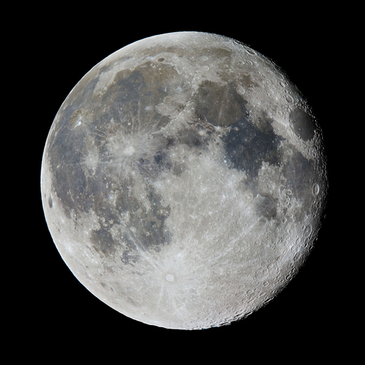
Moon Phase
Waning gibbous
Sunset
08:22 PM
Hourly Forecast
Wed, 03:00 PM
CloudyWinds: 10 mph WNW
63°
Wed, 04:00 PM
CloudyWinds: 10 mph WNW
63°
Wed, 05:00 PM
CloudyWinds: 10 mph WNW
63°
Wed, 06:00 PM
CloudyWinds: 10 mph WNW
63°
Wed, 07:00 PM
CloudyWinds: 10 mph WNW
61°
Wed, 08:00 PM
CloudyWinds: 10 mph WNW
61°
Wed, 09:00 PM
CloudyWinds: 10 mph WNW
61°
Wed, 10:00 PM
CloudyWinds: 10 mph WNW
61°
Wed, 11:00 PM
Patchy FogWinds: 10 mph NW
60°
Thu, 12:00 AM
Patchy FogWinds: 10 mph NW
60°
Thu, 01:00 AM
Patchy FogWinds: 10 mph NW
60°
Thu, 02:00 AM
Patchy FogWinds: 5 mph NW
58°
Thu, 03:00 AM
Patchy FogWinds: 5 mph NW
58°
Thu, 04:00 AM
Patchy FogWinds: 5 mph NW
56°
Thu, 05:00 AM
Patchy FogWinds: 5 mph WNW
53°
Thu, 06:00 AM
Patchy FogWinds: 5 mph WNW
53°
Thu, 07:00 AM
Patchy FogWinds: 5 mph WNW
55°
Thu, 08:00 AM
Patchy FogWinds: 0 mph
56°
Thu, 09:00 AM
Patchy FogWinds: 0 mph
59°
Thu, 10:00 AM
Patchy FogWinds: 0 mph
60°
Thu, 11:00 AM
Mostly CloudyWinds: 5 mph SSW
60°
Thu, 12:00 PM
Mostly CloudyWinds: 5 mph SSW
61°
Thu, 01:00 PM
Mostly CloudyWinds: 5 mph SSW
61°
Thu, 02:00 PM
Mostly CloudyWinds: 10 mph WNW
62°
Winds: 10 mph WNW
Cloudy, with a high near 63. West northwest wind around 10 mph.
Winds: 5 to 10 mph WNW
Patchy fog after 11pm. Cloudy, with a low around 53. West northwest wind 5 to 10 mph.
Winds: 0 to 10 mph W
Patchy fog before 11am. Mostly cloudy, with a high near 62. West wind 0 to 10 mph.
Winds: 5 to 10 mph NW
Patchy fog after 11pm. Cloudy, with a low around 53. Northwest wind 5 to 10 mph.
Winds: 5 to 10 mph NW
Patchy fog before 11am. Mostly cloudy, with a high near 64. Northwest wind 5 to 10 mph.
Winds: 5 to 10 mph NW
Patchy fog after 11pm. Cloudy, with a low around 53.
Winds: 5 to 10 mph NW
Patchy fog before 11am. Mostly cloudy, with a high near 65.
Winds: 5 mph NW
Mostly cloudy, with a low around 53.
Winds: 5 to 10 mph NW
Mostly cloudy, with a high near 60.
Winds: 5 to 10 mph NW
Mostly cloudy, with a low around 53.
Winds: 5 to 10 mph WNW
Partly sunny, with a high near 60.
Winds: 10 mph NW
Mostly cloudy, with a low around 54.
Winds: 10 to 15 mph NW
Partly sunny, with a high near 62.
Winds: 10 to 15 mph NW
Mostly cloudy, with a low around 55.
Coastal Waters Forecast for California
National Weather Service Los Angeles/Oxnard CA
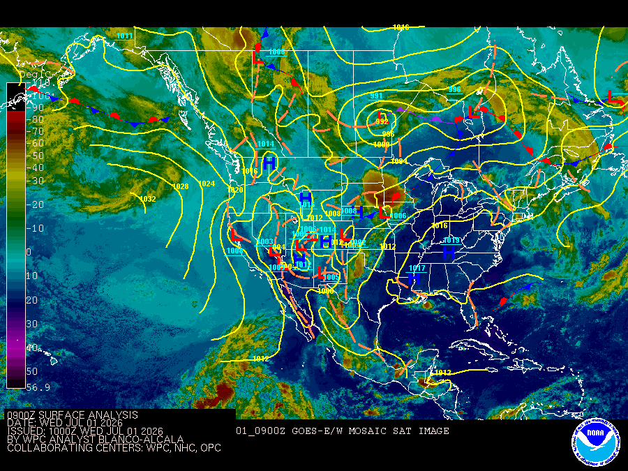
for the southern California coast and Santa Barbara Channel including the Channel Islands National Marine Sanctuary and National Park.at 18Z or 11 AM PDT, a 1030 mb surface high was 1000 NM west of Portland while a 1006 MB low was near Las Vegas.
Point Piedras Blancas to San Mateo Point CA out 60 NM including the Channel Islands National Marine Sanctuary See weather.gov/marine/wavedetail for more info on the new Wave Detail format.
TONIGHT
NW wind 10 to 15 kt, becoming 5 to 10 kt after midnight Seas 4 to 6 ft Wave Detail: NW 5 ft at 10 seconds and SW 2 ft at 15 seconds Patchy fog after midnight
THU
Light winds, becoming NW 10 to 15 kt in the afternoon Seas 4 to 5 ft Wave Detail: NW 4 ft at 10 seconds and SW 2 ft at 15 seconds Patchy fog in the morning
THU NIGHT
NW wind 10 to 15 kt, becoming 5 to 10 kt after midnight Seas 4 to 5 ft Wave Detail: NW 4 ft at 9 seconds and S 2 ft at 15 seconds Patchy fog after midnight
FRI
Light winds, becoming NW 10 to 15 kt in the afternoon Seas 3 to 4 ft Wave Detail: NW 4 ft at 9 seconds and S 2 ft at 15 seconds Patchy fog in the morning
FRI NIGHT
NW wind 10 to 15 kt in the evening, becoming light Seas 3 to 4 ft Wave Detail: NW 3 ft at 8 seconds and S 2 ft at 14 seconds Patchy fog after midnight
SAT
Light winds, becoming NW 10 to 15 kt in the afternoon Seas 3 to 4 ft Wave Detail: NW 3 ft at 8 seconds and S 2 ft at 14 seconds Patchy fog in the morning
SAT NIGHT
NW wind 10 to 15 kt, becoming 5 to 10 kt after midnight Seas 3 to 4 ft Wave Detail: NW 3 ft at 8 seconds and S 2 ft at 14 seconds
SUN
Light winds, becoming NW 10 to 15 kt in the afternoon Seas 3 to 4 ft Wave Detail: NW 3 ft at 8 seconds and S 2 ft at 14 seconds
SUN NIGHT
NW wind 10 to 15 kt, becoming 5 to 10 kt after midnight Seas 4 to 5 ft Wave Detail: NW 4 ft at 9 seconds and S 3 ft at 14 seconds
MON
NW wind 5 to 10 kt, becoming 10 to 15 kt with gusts to 20 kt in the afternoon Seas 4 to 6 ft Wave Detail: NW 5 ft at 9 seconds and S 3 ft at 15 seconds
MON NIGHT
NW wind 10 to 15 kt with gusts to 20 kt, becoming 5 to 10 kt after midnight Seas 6 to 8 ft Wave Detail: NW 6 ft at 8 seconds and S 3 ft at 15 seconds
TONIGHT
NW wind 10 to 15 kt with gusts to 20 kt Seas 6 to 8 ft Wave Detail: NW 7 ft at 9 seconds and S 2 ft at 15 seconds Patchy fog after midnight
THU
NW wind 10 to 15 kt Seas 6 to 8 ft Wave Detail: NW 7 ft at 9 seconds and S 2 ft at 16 seconds Patchy fog in the morning
THU NIGHT
NW wind 10 to 15 kt with gusts to 20 kt Seas 5 to 7 ft Wave Detail: NW 7 ft at 9 seconds and S 2 ft at 15 seconds Patchy fog after midnight
FRI
NW wind 10 to 15 kt with gusts to 20 kt Seas 5 to 7 ft Wave Detail: NW 6 ft at 9 seconds and S 2 ft at 15 seconds Patchy fog in the morning
FRI NIGHT
NW wind 10 to 15 kt with gusts to 20 kt Seas 5 to 6 ft Wave Detail: NW 5 ft at 8 seconds and S 2 ft at 14 seconds Patchy fog after midnight
SAT
NW wind 10 to 15 kt Seas 4 to 5 ft Wave Detail: NW 4 ft at 8 seconds and S 3 ft at 14 seconds Patchy fog in the morning
SAT NIGHT
NW wind 10 to 15 kt with gusts to 20 kt Seas 4 to 6 ft Wave Detail: NW 4 ft at 8 seconds and S 3 ft at 14 seconds
SUN
NW wind 10 to 15 kt with gusts to 20 kt Seas 5 to 6 ft Wave Detail: NW 5 ft at 9 seconds and S 3 ft at 14 seconds
SUN NIGHT
NW wind 10 to 15 kt with gusts to 20 kt Seas 5 to 7 ft Wave Detail: NW 6 ft at 9 seconds and S 3 ft at 14 seconds
MON
NW wind 10 to 15 kt with gusts to 20 kt Seas 6 to 7 ft Wave Detail: NW 6 ft at 8 seconds and S 3 ft at 15 seconds
MON NIGHT
NW wind 15 to 20 kt with gusts to 25 kt Seas 7 to 9 ft Wave Detail: NW 7 ft at 8 seconds and S 3 ft at 15 seconds
TONIGHT
NW wind 10 to 15 kt with gusts to 20 kt Seas 5 to 7 ft Wave Detail: NW 2 ft at 7 seconds, NW 6 ft at 10 seconds and S 2 ft at 15 seconds Patchy fog after midnight
THU
NW wind 5 to 10 kt, becoming 10 to 15 kt in the afternoon Seas 5 to 7 ft Wave Detail: NW 2 ft at 6 seconds, NW 7 ft at 10 seconds and S 2 ft at 16 seconds Patchy fog in the morning
THU NIGHT
NW wind 10 to 15 kt with gusts to 20 kt Seas 5 to 7 ft Wave Detail: NW 6 ft at 10 seconds and S 2 ft at 15 seconds Patchy fog after midnight
FRI
NW wind 10 to 15 kt with gusts to 20 kt Seas 4 to 6 ft Wave Detail: NW 5 ft at 8 seconds and S 2 ft at 15 seconds Patchy fog in the morning
FRI NIGHT
NW wind 10 to 15 kt with gusts to 20 kt Seas 4 to 6 ft Wave Detail: NW 5 ft at 9 seconds and S 2 ft at 14 seconds Patchy fog after midnight
SAT
NW wind 10 to 15 kt with gusts to 20 kt Seas 4 to 5 ft Wave Detail: NW 4 ft at 8 seconds and S 3 ft at 14 seconds Patchy fog in the morning
SAT NIGHT
NW wind 10 to 15 kt with gusts to 20 kt Seas 4 to 5 ft Wave Detail: NW 4 ft at 8 seconds and S 3 ft at 13 seconds
SUN
NW wind 10 to 15 kt with gusts to 20 kt Seas 4 to 5 ft Wave Detail: NW 4 ft at 8 seconds and S 3 ft at 14 seconds
SUN NIGHT
NW wind 15 to 20 kt with gusts to 25 kt Seas 5 to 7 ft Wave Detail: NW 6 ft at 9 seconds and S 3 ft at 14 seconds
MON
NW wind 15 to 20 kt with gusts to 25 kt Seas 6 to 7 ft Wave Detail: NW 6 ft a 8 seconds and S 3 ft at 15 seconds
MON NIGHT
NW wind 15 to 20 kt with gusts to 25 kt Seas 6 to 9 ft Wave Detail: NW 7 ft at 8 seconds and S 3 ft at 15 seconds
TONIGHT
NW wind 10 to 15 kt with gusts to 20 kt Seas 4 to 6 ft Wave Detail: NW 3 ft at 7 seconds, NW 4 ft at 10 seconds and S 2 ft at 16 seconds Patchy fog after midnight
THU
NW wind 5 to 10 kt, becoming 10 to 15 kt in the afternoon Seas 4 to 6 ft Wave Detail: NW 2 ft at 6 seconds, NW 5 ft at 9 seconds and S 2 ft at 15 seconds Patchy fog in the morning
THU NIGHT
NW wind 10 to 15 kt Seas 4 to 6 ft Wave Detail: NW 5 ft at 7 seconds and S 2 ft at 15 seconds Patchy fog after midnight
FRI
NW wind 10 to 15 kt Seas 4 to 6 ft Wave Detail: NW 4 ft at 8 seconds and S 3 ft at 15 seconds Patchy fog in the morning
FRI NIGHT
NW wind 10 to 15 kt with gusts to 20 kt Seas 4 to 5 ft Wave Detail: NW 4 ft at 6 seconds and S 3 ft at 14 seconds Patchy fog after midnight
SAT
NW wind 10 to 15 kt Seas 3 to 5 ft Wave Detail: NW 4 ft at 7 seconds and S 3 ft at 14 seconds Patchy fog in the morning
SAT NIGHT
NW wind 15 to 20 kt with gusts to 25 kt Seas 4 to 5 ft Wave Detail: NW 4 ft at 5 seconds and S 3 ft at 13 seconds
SUN
NW wind 15 to 20 kt with gusts to 25 kt Seas 4 to 6 ft Wave Detail: NW 5 ft at 7 seconds and S 3 ft at 14 seconds
SUN NIGHT
NW wind 15 to 20 kt with gusts to 25 kt Seas 5 to 7 ft Wave Detail: NW 6 ft at 7 seconds and S 3 ft at 14 seconds
MON
NW wind 15 to 20 kt with gusts to 25 kt Seas 5 to 7 ft Wave Detail: NW 6 ft at 7 seconds and S 3 ft at 15 seconds
MON NIGHT
NW wind 15 to 25 kt with gusts to 30 kt Seas 5 to 7 ft Wave Detail: NW 6 ft at 7 seconds and S 3 ft at 16 seconds
TONIGHT
Western portion, NW wind 10 to 15 kt with gusts to 20 kt Eastern portion, W wind 10 to 15 kt this evening, becoming light Seas 2 to 3 ft Wave Detail: W 2 ft at 6 seconds and W 2 ft at 9 seconds Patchy fog after midnight
THU
Light winds, becoming W 10 to 15 kt in the afternoon Seas 2 to 3 ft Wave Detail: W 2 ft at 8 seconds Patchy fog in the morning
THU NIGHT
W wind 10 to 15 kt in the evening, becoming light Seas 2 to 4 ft Wave Detail: W 3 ft at 5 seconds Patchy fog after midnight
FRI
Light winds, becoming W 10 to 15 kt in the afternoon Seas 2 to 3 ft Wave Detail: NW 2 ft at 6 seconds Patchy fog in the morning
FRI NIGHT
Western portion, NW wind 10 to 15 kt with gusts to 20 kt Eastern portion, W wind 10 to 15 kt in the evening, becoming light Seas 2 to 4 ft Wave Detail: W 3 ft at 5 seconds Patchy fog after midnight
SAT
Western portion, W wind 5 to 10 kt, becoming 10 to 15 kt with gusts to 20 kt in the afternoon Eastern portion, light winds, becoming W 10 to 15 kt in the afternoon Seas 2 to 3 ft Wave Detail: W 2 ft at 5 seconds Patchy fog in the morning
SAT NIGHT
Western Portion, NW wind 10 to 15 kt with gusts to 20 kt Eastern Portion, W wind 10 to 15 kt in the evening, becoming light Seas 2 to 3 ft Wave Detail: W 3 ft at 5 seconds
SUN
Western Portion, W wind 10 to 15 kt Eastern Portion, light winds, becoming W 10 to 15 kt in the afternoon Seas 2 to 3 ft Wave Detail: NW 2 ft at 6 seconds
SUN NIGHT
Western Portion, NW wind 15 to 20 kt with gusts to 25 kt Eastern Portion, W wind 10 to 15 kt in the evening, becoming light Seas 3 to 5 ft Wave Detail: W 4 ft at 6 seconds and S 2 ft at 15 seconds
MON
Western Portion, NW wind 10 to 15 kt with gusts to 20 kt Eastern Portion, light winds, becoming W 10 to 15 kt in the afternoon Seas 2 to 4 ft Wave Detail: W 3 ft at 7 seconds and SW 2 ft at 16 seconds
MON NIGHT
Western Portion, NW wind 15 to 20 kt with gusts to 25 kt Eastern Portion, W wind 10 to 15 kt in the evening, becoming light Seas 3 to 5 ft Wave Detail: W 4 ft at 6 seconds and SW 2 ft at 16 seconds
TONIGHT
W wind 10 to 15 kt, becoming 5 to 10 kt after midnight Seas 2 to 3 ft Wave Detail: NW 2 ft at 5 seconds and S 2 ft at 16 seconds Patchy fog after midnight
THU
Light winds, becoming W 10 to 15 kt in the afternoon Seas 2 to 3 ft Wave Detail: W 2 ft at 6 seconds and S 2 ft at 15 seconds Patchy fog in the morning
THU NIGHT
W wind 10 to 15 kt, becoming 5 to 10 kt after midnight Seas 2 to 4 ft Wave Detail: NW 3 ft at 5 seconds and S 2 ft at 15 seconds Patchy fog after midnight
FRI
Light winds, becoming W 10 to 15 kt in the afternoon Seas 2 to 4 ft Wave Detail: W 3 ft at 6 seconds and S 2 ft at 15 seconds Patchy fog in the morning
FRI NIGHT
W wind 10 to 15 kt, becoming 5 to 10 kt after midnight Seas 3 ft Wave Detail: W 3 ft at 5 seconds and S 2 ft at 14 seconds Patchy fog after midnight
SAT
Light winds, becoming W 10 to 15 kt in the afternoon Seas 2 to 3 ft Wave Detail: NW 2 ft at 6 seconds and S 2 ft at 14 seconds Patchy fog in the morning
SAT NIGHT
W wind 10 to 15 kt, becoming 5 to 10 kt after midnight Seas 3 to 4 ft Wave Detail: W 3 ft at 5 seconds and S 2 ft at 14 seconds
SUN
Light winds, becoming W 10 to 15 kt in the afternoon Seas 2 to 4 ft Wave Detail: W 3 ft at 6 seconds and S 2 ft at 14 seconds
SUN NIGHT
W wind 10 to 15 kt, becoming 5 to 10 kt after midnight Seas 3 to 5 ft Wave Detail: W 3 ft at 6 seconds and S 2 ft at 15 seconds
MON
Light winds, becoming W 10 to 15 kt in the afternoon Seas 3 to 4 ft Wave Detail: W 3 ft at 7 seconds and S 2 ft at 16 seconds
MON NIGHT
W wind 10 to 15 kt, becoming 5 to 10 kt after midnight Seas 3 to 5 ft Wave Detail: W 3 ft at 6 seconds and S 2 ft at 16 seconds
Reporting time
Oilrig
NWS
Buoy
Fixed Station
USGS
Ship
Other
Search Results
