Alerts
You have (1) alert(s). Tap to see details.
| Air Quality Alert issued August 2 at 3:31PM CDT by NWS Fort Worth TX | ||
| NWS Fort Worth TX | ||
| Category | Certainty | Severity |
| Met | Unknown | Unknown |
| Status | Urgency | Category |
| Actual | Unknown | Met |
| Effective | Ends | Expires |
| 08/02/2026 03:31 PM | 08/03/2026 10:05 AM | 08/03/2026 06:45 PM |
AQAFWD
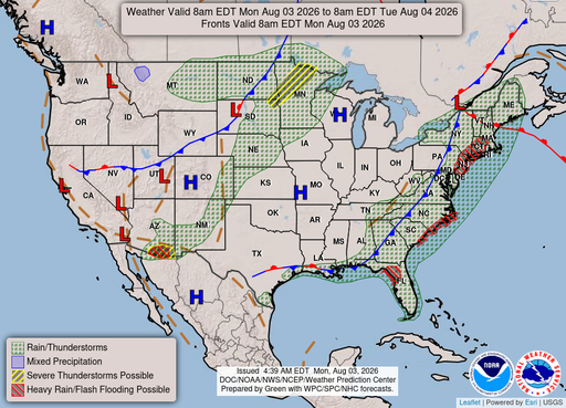
The Texas Commission on Environmental Quality (TCEQ) has issued
an Ozone Action Day for the Dallas-Fort Worth area for Monday,
August 3, 2026.
Atmospheric conditions are expected to be favorable for producing
high levels of ozone air pollution in the Dallas-Fort Worth area
on Monday. You can help prevent ozone pollution by sharing a
ride, walking, riding a bicycle, taking your lunch to work,
avoiding drive-through lanes, conserving energy, and keeping your
vehicle properly tuned.
For more information on ozone:
Ozone: The Facts (www.tceq.texas.gov/goto/ozonefacts)
Air North Texas: (www.airnorthtexas.org)
EPA Air Now
(www.airnow.gov/index.cfm?action.local_state&STATEID=45&TAB=0)
Take care of Texas (www.takecareoftexas.org)
North Central Texas Council of Governments Air Quality
(www.nctcog.org/trans/air/index.asp)
|
||

Hourly Forecast
Mon, 09:00 AM
SunnyWinds: 5 mph SSE
Mon, 10:00 AM
SunnyWinds: 5 mph SSE
Mon, 11:00 AM
SunnyWinds: 5 mph SSE
Mon, 12:00 PM
SunnyWinds: 5 mph SSE
Mon, 01:00 PM
SunnyWinds: 5 mph SSE
Mon, 02:00 PM
SunnyWinds: 5 mph SE
Mon, 03:00 PM
SunnyWinds: 5 mph SE
Mon, 04:00 PM
SunnyWinds: 5 mph SE
Mon, 05:00 PM
SunnyWinds: 5 mph SE
Mon, 06:00 PM
ClearWinds: 5 mph SE
Mon, 07:00 PM
ClearWinds: 5 mph SE
Mon, 08:00 PM
ClearWinds: 5 mph SE
Mon, 09:00 PM
ClearWinds: 10 mph ESE
Mon, 10:00 PM
ClearWinds: 10 mph ESE
Mon, 11:00 PM
ClearWinds: 10 mph ESE
Tue, 12:00 AM
ClearWinds: 10 mph SE
Tue, 01:00 AM
ClearWinds: 10 mph SE
Tue, 02:00 AM
ClearWinds: 5 mph SSE
Tue, 03:00 AM
ClearWinds: 5 mph SSE
Tue, 04:00 AM
ClearWinds: 5 mph S
Tue, 05:00 AM
ClearWinds: 5 mph S
Tue, 06:00 AM
SunnyWinds: 5 mph S
Tue, 07:00 AM
SunnyWinds: 5 mph S
Tue, 08:00 AM
SunnyWinds: 5 mph S
Coastal Waters Forecast for Texas
National Weather Service Houston/Galveston TX
For High Island to the Matagorda Ship Channel Out 60 NM including Galveston and Matagorda Bays. Light to moderate winds and low seas are expected through the forecast period. Winds this morning are expected to be west to southwest, before becoming more southerly as we approach mid week. By the end of the week, winds are expected to become more southeasterly.
Upper Texas coastal waters from High Island to the Matagorda Ship Channel out 60 nautical miles including Galveston and Matagorda Bays. Seas are provided as a range of the average height of the highest 1/3 of the waves.along with the occasional height of the average highest 10 percent of the waves.

Search Results
