Steinhatchee FL
04/19/2024 06:00 AM
65°F
TEMPERATURE
Winds 0 mph NW
Patchy Fog
Areas of fog before 10am. Sunny, with a high near 81. West northwest wind 0 to 10 mph.

Alerts

You have (1) alert(s). Tap to see details.

Special Weather Statement issued April 19 at 6:06AM EDT by NWS Tallahassee FL
NWS Tallahassee FL
Category Certainty Severity
Met Observed Moderate
Status Urgency Category
Actual Expected Met
Effective Ends Expires
04/19/2024 06:06 AM 04/19/2024 06:34 AM 04/19/2024 09:00 AM
Areas of fog, with localized areas of dense fog, has developed in
the predawn hours across portions of the area, especially across
Florida and adjacent southwest Georgia. Rapid changes in
visibilities can be expected when traveling through more fog prone
areas through morning commute. Drivers are urged to slow down if
encountering patches of fog and allow safe braking distance
between motorists. Conditions should rapidly improve by mid
morning.
                                            
Moonrise
05:30 PM
Moonset
05:55 AM
Sunrise
07:01 AM
Moon Phase
Waxing gibbous
Sunset
08:03 PM

Hourly Forecast

Fri, 06:00 AM

Patchy Fog
Winds: 0 mph NW
65°

Fri, 07:00 AM

Patchy Fog
Winds: 0 mph N
64°

Fri, 08:00 AM

Areas Of Fog
Winds: 0 mph N
65°

Fri, 09:00 AM

Patchy Fog
Winds: 0 mph NNW
70°

Fri, 10:00 AM

Sunny
Winds: 0 mph WNW
74°

Fri, 11:00 AM

Sunny
Winds: 0 mph W
78°

Fri, 12:00 PM

Sunny
Winds: 5 mph W
80°

Fri, 01:00 PM

Sunny
Winds: 5 mph W
81°

Fri, 02:00 PM

Sunny
Winds: 10 mph WSW
81°

Fri, 03:00 PM

Sunny
Winds: 10 mph WSW
81°

Fri, 04:00 PM

Sunny
Winds: 10 mph WSW
80°

Fri, 05:00 PM

Sunny
Winds: 10 mph WSW
79°

Fri, 06:00 PM

Mostly Clear
Winds: 10 mph WSW
77°

Fri, 07:00 PM

Mostly Clear
Winds: 10 mph WSW
75°

Fri, 08:00 PM

Mostly Clear
Winds: 5 mph WSW
72°

Fri, 09:00 PM

Mostly Clear
Winds: 5 mph WSW
71°

Fri, 10:00 PM

Mostly Clear
Winds: 5 mph WSW
69°

Fri, 11:00 PM

Mostly Clear
Winds: 5 mph WSW
68°

Sat, 12:00 AM

Mostly Clear
Winds: 5 mph W
68°

Sat, 01:00 AM

Partly Cloudy
Winds: 5 mph W
68°

Sat, 02:00 AM

Partly Cloudy
Winds: 5 mph W
67°

Sat, 03:00 AM

Partly Cloudy
Winds: 5 mph W
67°

Sat, 04:00 AM

Patchy Fog
Winds: 5 mph W
66°

Sat, 05:00 AM

Patchy Fog
Winds: 5 mph W
66°
Winds: 0 to 10 mph WNW
Areas of fog before 10am. Sunny, with a high near 81. West northwest wind 0 to 10 mph.
Winds: 5 to 10 mph W
Patchy fog after 4am. Partly cloudy. Low around 63, with temperatures rising to around 66 overnight. West wind 5 to 10 mph.
Winds: 0 to 10 mph W
Patchy fog before 9am. Mostly sunny. High near 82, with temperatures falling to around 78 in the afternoon. West wind 0 to 10 mph.
Winds: 0 to 10 mph WSW
Partly cloudy, with a low around 65. West southwest wind 0 to 10 mph.
Winds: 0 to 10 mph WSW
A slight chance of showers and thunderstorms after 2pm. Partly sunny, with a high near 80. West southwest wind 0 to 10 mph. Chance of precipitation is 20%.
Winds: 5 to 10 mph WNW
A slight chance of showers and thunderstorms before 8pm, then a chance of showers and thunderstorms. Mostly cloudy, with a low around 59. Chance of precipitation is 50%.
Winds: 5 to 10 mph NNW
A chance of rain showers before noon, then a slight chance of showers and thunderstorms between noon and 2pm. Mostly sunny, with a high near 76. Chance of precipitation is 30%.
Winds: 5 to 10 mph NNE
Mostly clear, with a low around 53.
Winds: 5 mph N
Sunny, with a high near 80.
Winds: 0 to 5 mph N
Mostly clear, with a low around 55.
Winds: 0 to 5 mph NNE
Sunny, with a high near 82.
Winds: 0 to 5 mph NW
Clear, with a low around 59.
Winds: 0 to 10 mph ENE
Sunny, with a high near 84.
Winds: 5 mph N
Mostly clear, with a low around 61.

Coastal Waters Forecast for Florida Big Bend and eastern Panhandle

National Weather Service Tallahassee FL

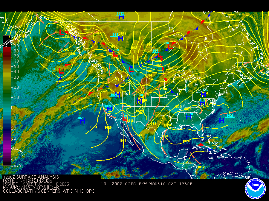
Gulf coastal waters from the mouth of the Suwannee River to Okaloosa-Walton County Line out to 60 nm. Seas are provided as a range of the average height of the highest 1/3 of the waves.along with the occasional height of the average highest 1/10 of the waves. Boating conditions look favorable heading into the weekend. Although, a cold front will be affecting our marine zones by Sunday with a few showers and perhaps thunderstorms, yet should be brief. Following the frontal passage, there may be a period of cautionary conditions moving from west to east during the morning hours on Monday. After the front, favorable conditions return with seas of 1-2 feet with winds averaging around 5-10 knots by midweek.

TODAY
West winds 5 to 10 knots Seas around 2 feet with a dominant period of 5 seconds Protected waters a light chop Patchy fog early this morning
TONIGHT
Southwest winds 5 to 10 knots Seas around 2 feet with a dominant period of 5 seconds Protected waters a light chop
SATURDAY
West winds around 5 knots, becoming southwest in the afternoon Seas around 2 feet with a dominant period of 5 seconds Protected waters a light chop
SATURDAY NIGHT
Southwest winds 5 to 10 knots Seas around 2 feet with a dominant period of 6 seconds Protected waters a light chop
SUNDAY
Southwest winds 5 to 10 knots Waves 1 foot or less, then around 2 feet with a dominant period of 5 seconds in the afternoon Protected waters a light chop A slight chance of showers in the morning, then a chance of showers with a slight chance of thunderstorms in the afternoon
SUNDAY NIGHT
West winds 10 to 15 knots, becoming north after midnight Seas 2 to 3 feet with a dominant period of 3 seconds Protected waters a moderate chop A chance of showers with a slight chance of thunderstorms
MONDAY
North winds 10 to 15 knots Seas 2 to 3 feet with a dominant period of 4 seconds Protected waters a moderate chop A slight chance of showers in the morning
MONDAY NIGHT
North winds around 10 knots, becoming northeast after midnight Seas around 2 feet with a dominant period of 3 seconds Protected waters a moderate chop
TUESDAY
East winds 10 to 15 knots, diminishing to 5 to 10 knots in the afternoon Seas around 2 feet with a dominant period of 3 seconds Protected waters a moderate chop
TUESDAY NIGHT
South winds 5 to 10 knots, becoming north after midnight Seas around 2 feet with a dominant period of 4 seconds in the evening, then 1 foot or less Protected waters a light chop
Reporting time 03:09 AM EDT Fri Apr 19 2024 /209 AM CDT Fri Apr 19 2024/
Oilrig
NWS
Buoy
Fixed Station
USGS
Ship
Other