Hourly Forecast
Mon, 06:00 AM
Scattered Rain ShowersWinds: 9 mph ENE
Mon, 07:00 AM
Scattered Rain ShowersWinds: 9 mph NNE
Mon, 08:00 AM
Isolated Rain ShowersWinds: 9 mph N
Mon, 09:00 AM
Mostly CloudyWinds: 9 mph N
Mon, 10:00 AM
Mostly CloudyWinds: 10 mph N
Mon, 11:00 AM
Partly SunnyWinds: 10 mph N
Mon, 12:00 PM
Partly SunnyWinds: 10 mph N
Mon, 01:00 PM
Partly SunnyWinds: 10 mph N
Mon, 02:00 PM
Partly SunnyWinds: 12 mph N
Mon, 03:00 PM
Mostly CloudyWinds: 13 mph N
Mon, 04:00 PM
Partly SunnyWinds: 14 mph N
Mon, 05:00 PM
Mostly CloudyWinds: 15 mph N
Mon, 06:00 PM
Mostly CloudyWinds: 15 mph N
Mon, 07:00 PM
Mostly CloudyWinds: 16 mph N
Mon, 08:00 PM
Mostly CloudyWinds: 17 mph N
Mon, 09:00 PM
Mostly CloudyWinds: 17 mph N
Mon, 10:00 PM
Mostly CloudyWinds: 18 mph N
Mon, 11:00 PM
Mostly CloudyWinds: 18 mph N
Tue, 12:00 AM
Mostly CloudyWinds: 18 mph NNE
Tue, 01:00 AM
Mostly CloudyWinds: 18 mph NNE
Tue, 02:00 AM
Mostly CloudyWinds: 20 mph NNE
Tue, 03:00 AM
Mostly CloudyWinds: 18 mph NNE
Tue, 04:00 AM
Mostly CloudyWinds: 18 mph NNE
Tue, 05:00 AM
Mostly CloudyWinds: 18 mph NNE
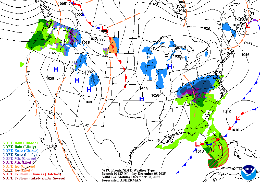
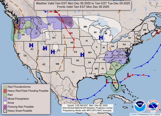
Coastal Waters Forecast for Florida
National Weather Service Tampa Bay Ruskin FL
A cold front will push across the waters today with scattered showers through the morning hours. High pressure will build over the region behind the front tonight and Tuesday with north to northwest winds increasing to cautionary levels. Winds and seas will gradually subside late Tuesday and Tuesday night. High pressure and benign conditions will hold over the waters the remainder of the week.
Gulf coastal waters from Bonita Beach to the mouth of the Suwannee River out to 60 NM. Important notice to mariners.marine forecasts are issued at least four times a day. Boaters on extended trips should routinely monitor subsequent forecast issuances and updates for the latest marine weather information. The wave heights are forecast as significant wave height which is the average of the highest one-third of the waves. The highest waves may rarely be twice the significant wave height. The winds and seas near thunderstorms may be higher than forecast. &&
Search Results
