Alerts
You have (1) alert(s). Tap to see details.
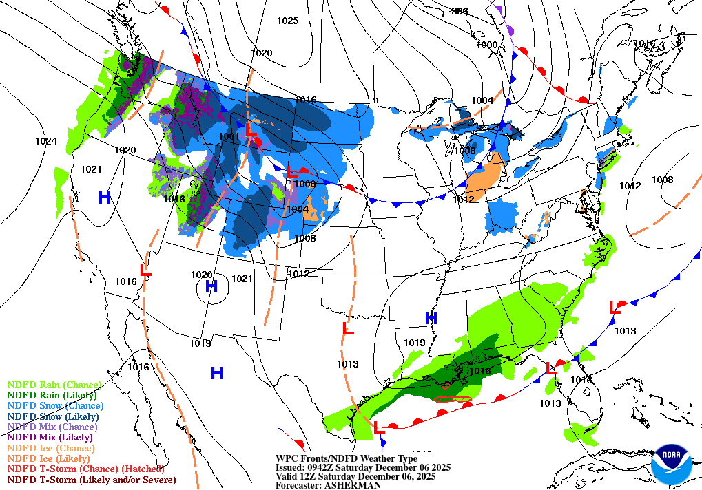
| Dense Fog Advisory issued December 6 at 12:11AM EST until December 6 at 10:00AM EST by NWS Tampa Bay Ruskin FL | ||
| NWS Tampa Bay Ruskin FL | ||
| Category | Certainty | Severity |
| Met | Likely | Moderate |
| Status | Urgency | Category |
| Actual | Expected | Met |
| Effective | Ends | Expires |
| 12/06/2025 12:11 AM | 12/06/2025 10:00 AM | 12/06/2025 10:00 AM |
* WHAT...Visibility one quarter mile or less in dense fog.

* WHERE...Portions of southwest and west central Florida.

* WHEN...Until 10 AM EST this morning.

* IMPACTS...Low visibility could make driving conditions hazardous.
|
||
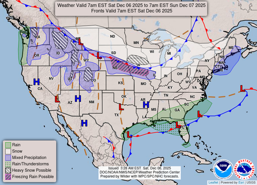
Hourly Forecast
Sat, 08:00 AM
Areas Of FogWinds: 7 mph S
Sat, 09:00 AM
CloudyWinds: 8 mph S
Sat, 10:00 AM
Mostly CloudyWinds: 9 mph SSW
Sat, 11:00 AM
Chance Rain ShowersWinds: 9 mph SSW
Sat, 12:00 PM
Chance Rain ShowersWinds: 9 mph SSW
Sat, 01:00 PM
Chance Rain ShowersWinds: 10 mph SSW
Sat, 02:00 PM
Chance Rain ShowersWinds: 10 mph SSW
Sat, 03:00 PM
Slight Chance Rain ShowersWinds: 9 mph SW
Sat, 04:00 PM
Chance Rain ShowersWinds: 9 mph SW
Sat, 05:00 PM
Chance Rain ShowersWinds: 9 mph SW
Sat, 06:00 PM
Chance Rain ShowersWinds: 7 mph SW
Sat, 07:00 PM
Chance Rain ShowersWinds: 6 mph SSW
Sat, 08:00 PM
Chance Rain ShowersWinds: 6 mph S
Sat, 09:00 PM
Chance Rain ShowersWinds: 6 mph S
Sat, 10:00 PM
Chance Rain ShowersWinds: 6 mph E
Sat, 11:00 PM
Chance Rain ShowersWinds: 6 mph E
Sun, 12:00 AM
Slight Chance Rain ShowersWinds: 6 mph E
Sun, 01:00 AM
Slight Chance Rain ShowersWinds: 6 mph E
Sun, 02:00 AM
Slight Chance Rain ShowersWinds: 6 mph E
Sun, 03:00 AM
Slight Chance Rain ShowersWinds: 6 mph E
Sun, 04:00 AM
Slight Chance Rain ShowersWinds: 7 mph E
Sun, 05:00 AM
Slight Chance Rain ShowersWinds: 7 mph E
Sun, 06:00 AM
Mostly CloudyWinds: 7 mph ESE
Sun, 07:00 AM
Chance Showers And ThunderstormsWinds: 7 mph ESE
Coastal Waters Forecast for Florida
National Weather Service Tampa Bay Ruskin FL
High pressure east of the Florida peninsula will create south to southwest winds across the waters today and Sunday. A few showers will be possible mainly north of Tampa Bay. A cold front will push across the waters late Sunday and Sunday night with showers and possibly a few thunderstorms. High pressure will build over the region behind the front early next week with north to northwest winds increasing to cautionary levels. Winds and seas will gradually subside Tuesday and Tuesday night.
Gulf coastal waters from Bonita Beach to the mouth of the Suwannee River out to 60 NM. Important notice to mariners.marine forecasts are issued at least four times a day. Boaters on extended trips should routinely monitor subsequent forecast issuances and updates for the latest marine weather information. The wave heights are forecast as significant wave height which is the average of the highest one-third of the waves. The highest waves may rarely be twice the significant wave height. The winds and seas near thunderstorms may be higher than forecast. &&
Search Results
