Ocean Breeze Park FL
05/04/2026 04:00 PM
77°F
TEMPERATURE
Winds 15 mph ENE
Mostly Cloudy
Mostly cloudy, with a high near 78. East northeast wind around 15 mph, with gusts as high as 25 mph. New rainfall amounts less than a tenth of an inch possible.

Alerts

You have (1) alert(s). Tap to see details.

Rip Current Statement issued May 4 at 2:03AM EDT until May 5 at 2:00AM EDT by NWS Melbourne FL
NWS Melbourne FL
Category Certainty Severity
Met Likely Moderate
Status Urgency Category
Actual Expected Met
Effective Ends Expires
05/04/2026 02:03 AM 05/05/2026 02:00 AM 05/05/2026 02:00 AM
* WHAT...Dangerous rip currents and rough surf.

* WHERE...The beaches of Volusia, Brevard, Indian River, Saint
Lucie, and Martin counties.

* WHEN...Through late tonight.

* IMPACTS...Rip currents can sweep even the best swimmers away
from shore into deeper water.
                                            
Moonrise
11:59 PM
Moonset
09:22 AM
Sunrise
06:39 AM
Moon Phase
Waning gibbous
Sunset
07:56 PM

Hourly Forecast

Mon, 04:00 PM

Mostly Cloudy
Winds: 15 mph ENE
77°

Mon, 05:00 PM

Mostly Cloudy
Winds: 15 mph ENE
76°

Mon, 06:00 PM

Mostly Cloudy
Winds: 15 mph ENE
76°

Mon, 07:00 PM

Mostly Cloudy
Winds: 15 mph ENE
75°

Mon, 08:00 PM

Mostly Cloudy
Winds: 10 mph ENE
74°

Mon, 09:00 PM

Partly Cloudy
Winds: 10 mph ENE
73°

Mon, 10:00 PM

Slight Chance Showers And Thunderstorms
Winds: 10 mph E
73°

Mon, 11:00 PM

Chance Showers And Thunderstorms
Winds: 10 mph E
73°

Tue, 12:00 AM

Chance Showers And Thunderstorms
Winds: 10 mph E
74°

Tue, 01:00 AM

Chance Showers And Thunderstorms
Winds: 10 mph E
73°

Tue, 02:00 AM

Chance Showers And Thunderstorms
Winds: 5 mph E
72°

Tue, 03:00 AM

Chance Showers And Thunderstorms
Winds: 5 mph E
72°

Tue, 04:00 AM

Slight Chance Showers And Thunderstorms
Winds: 5 mph E
71°

Tue, 05:00 AM

Slight Chance Showers And Thunderstorms
Winds: 5 mph E
70°

Tue, 06:00 AM

Slight Chance Showers And Thunderstorms
Winds: 5 mph E
71°

Tue, 07:00 AM

Slight Chance Showers And Thunderstorms
Winds: 5 mph E
71°

Tue, 08:00 AM

Slight Chance Showers And Thunderstorms
Winds: 5 mph E
72°

Tue, 09:00 AM

Slight Chance Showers And Thunderstorms
Winds: 5 mph E
76°

Tue, 10:00 AM

Slight Chance Showers And Thunderstorms
Winds: 5 mph E
77°

Tue, 11:00 AM

Slight Chance Rain Showers
Winds: 10 mph E
79°

Tue, 12:00 PM

Slight Chance Rain Showers
Winds: 10 mph E
79°

Tue, 01:00 PM

Mostly Sunny
Winds: 10 mph E
79°

Tue, 02:00 PM

Slight Chance Rain Showers
Winds: 10 mph E
79°

Tue, 03:00 PM

Mostly Sunny
Winds: 10 mph E
81°
Winds: 15 mph ENE
Mostly cloudy, with a high near 78. East northeast wind around 15 mph, with gusts as high as 25 mph. New rainfall amounts less than a tenth of an inch possible.
Winds: 5 to 15 mph E
A slight chance of showers and thunderstorms between 10pm and 11pm, then a chance of showers and thunderstorms between 11pm and 4am, then a slight chance of showers and thunderstorms. Mostly cloudy, with a low around 69. East wind 5 to 15 mph, with gusts as high as 25 mph. Chance of precipitation is 40%. New rainfall amounts less than a tenth of an inch possible.
Winds: 5 to 10 mph E
A slight chance of showers and thunderstorms before 3pm. Mostly sunny, with a high near 81. East wind 5 to 10 mph. Chance of precipitation is 20%. New rainfall amounts less than a tenth of an inch possible.
Winds: 5 to 10 mph ESE
Partly cloudy, with a low around 71. East southeast wind 5 to 10 mph.
Winds: 5 to 10 mph ESE
Mostly sunny, with a high near 85. East southeast wind 5 to 10 mph.
Winds: 5 to 10 mph SE
Partly cloudy, with a low around 71. Southeast wind 5 to 10 mph.
Winds: 5 to 10 mph S
Mostly sunny, with a high near 90. South wind 5 to 10 mph.
Winds: 5 to 10 mph SSW
Partly cloudy, with a low around 71. South southwest wind 5 to 10 mph.
Winds: 5 to 10 mph SW
Mostly sunny, with a high near 88. Southwest wind 5 to 10 mph.
Winds: 5 to 10 mph SSE
Mostly cloudy, with a low around 73. South southeast wind 5 to 10 mph.
Winds: 5 to 10 mph S
A slight chance of rain showers between 8am and 2pm, then a chance of showers and thunderstorms. Partly sunny, with a high near 89. South wind 5 to 10 mph. Chance of precipitation is 40%.
Winds: 5 to 10 mph SSE
A chance of showers and thunderstorms before 2am. Mostly cloudy, with a low around 74. South southeast wind 5 to 10 mph. Chance of precipitation is 40%.
Winds: 5 to 10 mph SE
A chance of showers and thunderstorms after 8am. Partly sunny, with a high near 87. Southeast wind 5 to 10 mph. Chance of precipitation is 40%.
Winds: 5 to 10 mph SSE
A chance of showers and thunderstorms before 8pm, then a chance of showers and thunderstorms. Mostly cloudy, with a low around 74. South southeast wind 5 to 10 mph.

Coastal Waters Forecast for East Central Florida

National Weather Service Melbourne FL
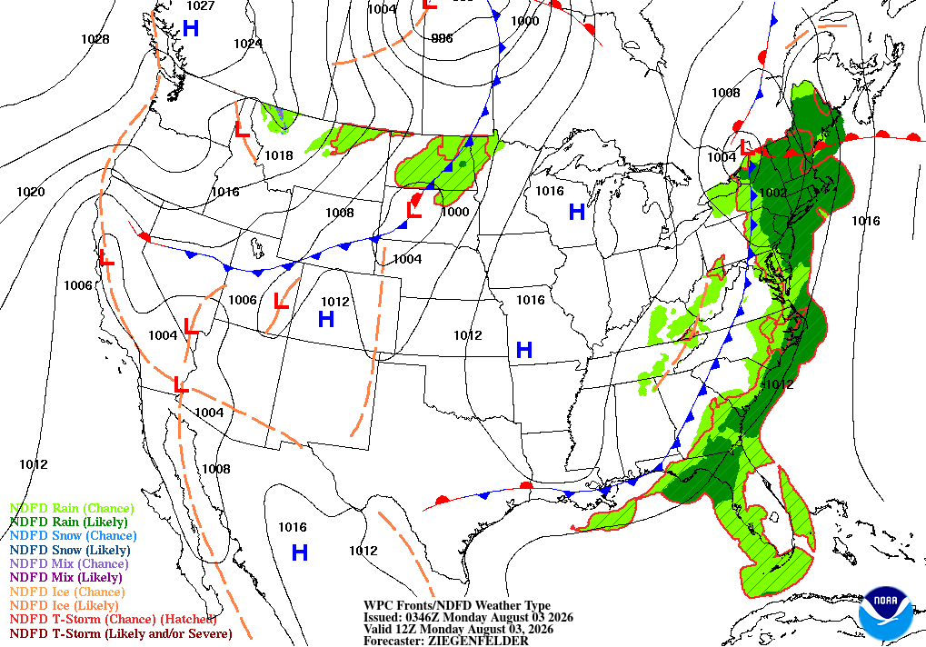
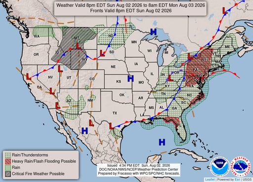
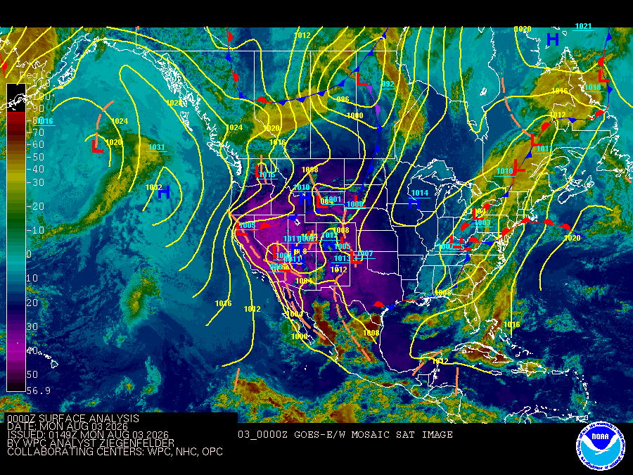
A moderate to fresh onshore breeze will lead to poor to hazardous boating conditions across much of the coastal waters today. As ridge axis of high pressure settles southward across and eventually south of the region through midweek, boating conditions are forecast to improve. Scattered showers with isolated storms are forecast through Tuesday, mainly south of Cape Canaveral.

Atlantic coastal waters from Flagler Beach to Jupiter Inlet out 60 nm. Seas are provided as a range of the average height of the highest one third of the waves, along with the occasional height of the average highest ten percent of the waves. GULF STREAM HAZARDS.East-northeast winds 15 to 25 knots and seas 6 to 8 feet through this evening. The approximate location of the west wall of the Gulf Stream based on the Real Time Ocean Forecast System as of Monday, May 4th, 2026. 46 nautical miles east of Ponce Inlet. 33 nautical miles east of Port Canaveral. 28 nautical miles east of Sebastian Inlet. 21 nautical miles east of Fort Pierce Inlet. 15 nautical miles east of Saint Lucie Inlet.

TONIGHT
East winds 10 to 15 knots, diminishing to 5 to 10 knots late Seas 3 to 4 feet Wave Detail: East 4 feet at 7 seconds A light chop on the intracoastal waters
TUESDAY
East winds 5 to 10 knots Seas 3 feet Wave Detail: East 3 feet at 7 seconds A light chop on the intracoastal waters
TUESDAY NIGHT
Southeast winds 10 to 15 knots, diminishing to 5 to 10 knots after midnight Seas 2 to 3 feet Wave Detail: East 3 feet at 7 seconds A light chop on the intracoastal waters
WEDNESDAY
South winds 5 to 10 knots, becoming southeast 15 to 20 knots in the afternoon Seas 2 to 3 feet Wave Detail: Southeast 2 feet at 3 seconds and east 2 feet at 7 seconds Choppy on the intracoastal waters
WEDNESDAY NIGHT
South winds 15 to 20 knots, diminishing to 10 to 15 knots after midnight Seas 2 to 3 feet Wave Detail: East 3 feet at 6 seconds and southeast 2 feet at 3 seconds Choppy on the intracoastal waters
THURSDAY
South winds 10 to 15 knots Seas 2 feet Wave Detail: South 2 feet at 3 seconds and east 2 feet at 7 seconds A moderate chop on the intracoastal waters
THURSDAY NIGHT
Southwest winds 10 to 15 knots, becoming west after midnight Seas 2 to 3 feet A light chop on the intracoastal waters
FRIDAY
Northwest winds 5 to 10 knots, becoming northeast in the afternoon Seas 2 to 3 feet A light chop on the intracoastal waters A slight chance of showers and thunderstorms in the afternoon
FRIDAY NIGHT
Southeast winds 5 to 10 knots, becoming southwest after midnight Seas 2 to 3 feet Mostly smooth on the intracoastal waters A slight chance of thunderstorms in the evening A chance of showers
SATURDAY
West winds 5 to 10 knots, becoming northeast in the afternoon Seas 2 to 3 feet A light chop on the intracoastal waters A chance of showers A chance of thunderstorms in the afternoon
SATURDAY NIGHT
East winds 5 to 10 knots, becoming southeast after midnight Seas 2 feet Mostly smooth on the intracoastal waters A slight chance of showers and thunderstorms in the evening
Reporting time 02:53 PM EDT Mon May 4 2026
SMALL CRAFT SHOULD EXERCISE CAUTION
Reporting time 02:53 PM EDT Mon May 4 2026
SMALL CRAFT ADVISORY IN EFFECT UNTIL 8 PM EDT THIS EVENING
Reporting time 02:53 PM EDT Mon May 4 2026
TONIGHT
East winds 10 to 15 knots Seas 3 to 5 feet, occasionally to 6 feet Wave Detail: East 4 feet at 7 seconds
TUESDAY
East winds around 10 knots Seas 3 feet Wave Detail: East 3 feet at 7 seconds
TUESDAY NIGHT
Southeast winds 5 to 10 knots Seas 2 to 3 feet Wave Detail: East 3 feet at 7 seconds
WEDNESDAY
South winds 5 to 10 knots, becoming southeast 10 to 15 knots in the afternoon Seas 2 to 3 feet Wave Detail: East 3 feet at 7 seconds
WEDNESDAY NIGHT
South winds 10 to 15 knots Seas 3 feet Wave Detail: East 3 feet at 7 seconds and south 2 feet at 4 seconds
THURSDAY
South winds 10 to 15 knots Seas 2 to 3 feet Wave Detail: South 2 feet at 4 seconds and east 2 feet at 7 seconds
THURSDAY NIGHT
Southwest winds 10 to 15 knots, becoming west after midnight Seas 2 to 3 feet
FRIDAY
Northwest winds 10 to 15 knots, becoming northeast 5 to 10 knots in the afternoon Seas 2 to 3 feet A slight chance of showers and thunderstorms in the afternoon
FRIDAY NIGHT
Southeast winds 10 to 15 knots, becoming southwest after midnight Seas 3 to 4 feet A chance of showers with a slight chance of thunderstorms
SATURDAY
West winds 10 to 15 knots, becoming east 5 to 10 knots in the afternoon Seas 3 to 4 feet A chance of showers A slight chance of thunderstorms in the morning, then a chance of thunderstorms in the afternoon
SATURDAY NIGHT
Southeast winds 10 to 15 knots Seas 2 to 3 feet A slight chance of showers and thunderstorms
Reporting time 02:53 PM EDT Mon May 4 2026
SMALL CRAFT ADVISORY IN EFFECT UNTIL 8 PM EDT THIS EVENING
Reporting time 02:53 PM EDT Mon May 4 2026
SMALL CRAFT ADVISORY IN EFFECT UNTIL 8 PM EDT THIS EVENING
Reporting time 02:53 PM EDT Mon May 4 2026
Oilrig
NWS
Buoy
Fixed Station
USGS
Ship
Other