Virginia Gardens FL
11/21/2025 12:00 AM
72°F
TEMPERATURE
Winds 3 mph NE
Mostly Clear
Mostly clear, with a low around 70. Northeast wind around 3 mph.
Moonrise
07:06 AM
Moonset
05:39 PM
Sunrise
06:43 AM
Moon Phase
Waxing crescent
Sunset
05:30 PM

Hourly Forecast

Fri, 12:00 AM

Mostly Clear
Winds: 3 mph NE
72°

Fri, 01:00 AM

Mostly Clear
Winds: 3 mph NE
72°

Fri, 02:00 AM

Mostly Clear
Winds: 3 mph NE
71°

Fri, 03:00 AM

Mostly Clear
Winds: 2 mph NE
71°

Fri, 04:00 AM

Partly Cloudy
Winds: 2 mph NE
70°

Fri, 05:00 AM

Mostly Clear
Winds: 2 mph NE
70°

Fri, 06:00 AM

Sunny
Winds: 2 mph NE
70°

Fri, 07:00 AM

Sunny
Winds: 2 mph NE
70°

Fri, 08:00 AM

Sunny
Winds: 3 mph NE
72°

Fri, 09:00 AM

Mostly Sunny
Winds: 5 mph NE
76°

Fri, 10:00 AM

Mostly Sunny
Winds: 6 mph E
79°

Fri, 11:00 AM

Sunny
Winds: 7 mph E
81°

Fri, 12:00 PM

Sunny
Winds: 8 mph E
82°

Fri, 01:00 PM

Mostly Sunny
Winds: 9 mph E
82°

Fri, 02:00 PM

Sunny
Winds: 9 mph E
81°

Fri, 03:00 PM

Sunny
Winds: 9 mph E
81°

Fri, 04:00 PM

Sunny
Winds: 9 mph E
80°

Fri, 05:00 PM

Sunny
Winds: 8 mph E
79°

Fri, 06:00 PM

Partly Cloudy
Winds: 7 mph E
77°

Fri, 07:00 PM

Partly Cloudy
Winds: 6 mph E
76°

Fri, 08:00 PM

Mostly Clear
Winds: 5 mph E
74°

Fri, 09:00 PM

Partly Cloudy
Winds: 5 mph NE
73°

Fri, 10:00 PM

Partly Cloudy
Winds: 3 mph NE
73°

Fri, 11:00 PM

Partly Cloudy
Winds: 2 mph NE
72°
Winds: 3 mph NE
Mostly clear, with a low around 70. Northeast wind around 3 mph.
Winds: 2 to 9 mph NE
Sunny, with a high near 82. Northeast wind 2 to 9 mph.
Winds: 2 to 7 mph NE
Partly cloudy, with a low around 69. Northeast wind 2 to 7 mph.
Winds: 2 to 6 mph NE
Mostly sunny, with a high near 83. Northeast wind 2 to 6 mph.
Winds: 1 to 5 mph NE
Mostly clear, with a low around 67. Northeast wind 1 to 5 mph.
Winds: 5 mph NE
Sunny, with a high near 84. Northeast wind around 5 mph.
Winds: 3 mph NE
Mostly clear, with a low around 68. Northeast wind around 3 mph.
Winds: 2 to 9 mph NE
Sunny, with a high near 82. Northeast wind 2 to 9 mph.
Winds: 7 mph E
Mostly clear, with a low around 71. East wind around 7 mph.
Winds: 5 to 10 mph E
Sunny, with a high near 83.
Winds: 7 mph E
Mostly clear, with a low around 72.
Winds: 5 to 9 mph SE
Sunny, with a high near 84.
Winds: 6 mph SE
Partly cloudy, with a low around 72.
Winds: 3 to 8 mph SE
Partly sunny, with a high near 83.

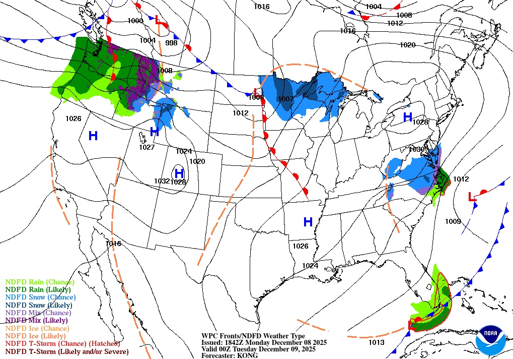
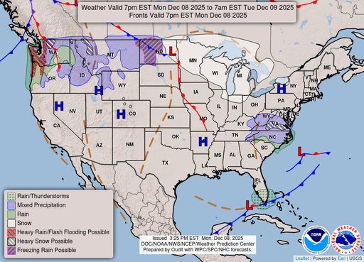
Coastal Waters Forecast for Florida

National Weather Service Miami FL

for Jupiter Inlet to Ocean Reef FL out to 60 nm and for East Cape Sable to Bonita Beach FL out to 60 nm.

Atlantic coastal waters from Jupiter Inlet to Ocean Reef out to 60 nm and Gulf coastal waters from East Cape Sable to Chokoloskee out 20 nm and Chokoloskee to Bonita Beach out 60 nm.including the waters of Biscayne Bay and Lake Okeechobee. Seas are provided as a range of the average height of the highest 1/3 of the waves.along with the occasional height of the average highest 10 percent of the waves. A gentle to moderate northeasterly wind flow is expected across most of the local waters through much of this week. Wave heights across local waters will remain at 2 feet or less over the next few days. A few showers will be possible across Atlantic waters each day, although primarily dry conditions should prevail overall. Gulf Stream Hazards: None. The approximate location of the west wall of the Gulf Stream as of Nov 20, 2025. 36 nautical miles north northeast of Fowey Rocks. 7 nautical miles east of Port Everglades. 6 nautical miles south southeast of Lake Worth. 11 nautical miles east southeast of Jupiter Inlet. This data courtesy of the Naval Oceanographic Office.

TODAY
NE winds 5 to 10 kt Seas around 2 ft Wave Detail: NE 2 ft at 3 seconds and N 1 foot at 7 seconds Intracoastal waters light chop
TONIGHT
E winds 5 to 10 kt Seas around 2 ft Wave Detail: NE 2 ft at 3 seconds and NW 1 foot at 7 seconds Intracoastal waters light chop
FRI
E winds 5 to 10 kt Seas around 2 ft Wave Detail: E 1 foot at 3 seconds and NW 1 foot at 4 seconds Intracoastal waters light chop
FRI NIGHT
E winds 5 to 10 kt Seas around 2 ft in the evening, then 1 foot or less Wave Detail: E 1 foot at 3 seconds Intracoastal waters light chop
SAT
E winds around 5 kt Seas less than 2 ft or less, then around 2 ft in the afternoon Wave Detail: E 1 foot at 3 seconds and N 1 foot at 5 seconds, becoming E 1 foot at 3 seconds and N 1 foot at 6 seconds Intracoastal waters smooth
SAT NIGHT
E winds around 5 kt, becoming SW around 5 kt after midnight Seas around 2 ft in the evening, then 1 foot or less Wave Detail: E 1 foot at 3 seconds and N 1 foot at 6 seconds, becoming E 1 foot at 2 seconds and N 1 foot at 7 seconds Intracoastal waters smooth
SUN THROUGH MON
E winds 10 to 15 kt Seas around 2 ft Intracoastal waters a moderate chop
Reporting time 11:40 PM EST Thu Nov 20 2025
TODAY
NE winds 10 to 15 kt Seas around 2 ft Wave Detail: NE 2 ft at 5 seconds Intracoastal waters a moderate chop
TONIGHT
E winds 10 to 15 kt Seas 2 to 3 ft Wave Detail: NE 2 ft at 4 seconds Intracoastal waters a moderate chop
FRI
E winds around 10 kt Seas around 2 ft Wave Detail: E 2 ft at 4 seconds Intracoastal waters light chop
FRI NIGHT
E winds 5 to 10 kt Seas around 2 ft Wave Detail: NE 2 ft at 3 seconds Intracoastal waters light chop
SAT AND SAT NIGHT
NE winds 5 to 10 kt Seas less than 2 ft or less Wave Detail: E 1 foot at 3 seconds Intracoastal waters light chop
SUN THROUGH MON
E winds 10 to 15 kt Seas around 2 ft Wave Detail: E 2 ft at 3 seconds Intracoastal waters a moderate chop
Reporting time 11:40 PM EST Thu Nov 20 2025
TODAY
NE winds 5 to 10 kt, becoming NW late Seas less than 2 ft or less Wave Detail: NE 1 foot at 2 seconds Bay and inland waters light chop
TONIGHT
N winds 5 to 10 kt, becoming E after midnight Seas less than 2 ft or less Wave Detail: E 1 foot at 2 seconds Bay and inland waters light chop
FRI
E winds 5 to 10 kt, becoming N in the afternoon Seas less than 2 ft or less Wave Detail: E 1 foot at 2 seconds Bay and inland waters light chop
FRI NIGHT
NE winds around 5 kt Seas less than 2 ft or less Bay and inland waters smooth
SAT AND SAT NIGHT
N winds 5 to 10 kt Seas less than 2 ft or less Bay and inland waters light chop
SUN THROUGH MON
E winds 5 to 10 kt Seas less than 2 ft or less Bay and inland waters light chop
Reporting time 11:40 PM EST Thu Nov 20 2025
TODAY
NE winds 5 to 10 kt Lake waters light chop
TONIGHT
E winds 5 to 10 kt, diminishing to around 5 kt after midnight Lake waters light chop
FRI
NE winds around 5 kt Lake waters smooth
FRI NIGHT
E winds 5 to 10 kt, diminishing to around 5 kt after midnight Lake waters light chop
SAT
N winds around 5 kt Lake waters smooth
SAT NIGHT
SE winds around 5 kt, becoming W around 5 kt after midnight Lake waters smooth
SUN THROUGH MON
E winds 5 to 10 kt Lake waters light chop
Reporting time 11:40 PM EST Thu Nov 20 2025
TODAY
NE winds 5 to 10 kt Light chop
TONIGHT
NE winds 10 to 15 kt, becoming E 5 to 10 kt after midnight A moderate chop
FRI
E winds 5 to 10 kt Light chop
FRI NIGHT
E winds 5 to 10 kt Light chop
SAT
NE winds around 5 kt Smooth
SAT NIGHT
E winds around 5 kt, becoming N after midnight Smooth
SUN THROUGH MON
E winds 5 to 10 kt Light chop
Reporting time 11:40 PM EST Thu Nov 20 2025
Oilrig
NWS
Buoy
Fixed Station
USGS
Ship
Other