Tampa, FL
02/04/2026 04:00 PM
62°F
TEMPERATURE
Winds 10 mph SSW
Sunny
Sunny, with a high near 63. South southwest wind around 10 mph.

Alerts

You have (1) alert(s). Tap to see details.

Small Craft Advisory issued February 4 at 8:18AM EST until February 6 at 6:00AM EST by NWS Tampa Bay Ruskin FL
NWS Tampa Bay Ruskin FL
Category Certainty Severity
Met Likely Minor
Status Urgency Category
Actual Expected Met
Effective Ends Expires
02/04/2026 08:18 AM 02/06/2026 06:00 AM 02/06/2026 06:00 AM
* WHAT...Northwest winds 15 to 25 knots with gusts up to 30
knots and seas 5 to 8 feet expected.

* WHERE...Portions of Gulf of America.

* WHEN...From 8 AM Thursday to 6 AM EST Friday.

* IMPACTS...Conditions will be hazardous to small craft.
                                            
Moonrise
09:12 PM
Moonset
08:56 AM
Sunrise
07:14 AM
Moon Phase
Waning gibbous
Sunset
06:13 PM

Hourly Forecast

Wed, 04:00 PM

Sunny
Winds: 10 mph SSW
62°

Wed, 05:00 PM

Sunny
Winds: 10 mph SSW
61°

Wed, 06:00 PM

Mostly Clear
Winds: 9 mph SSW
60°

Wed, 07:00 PM

Mostly Clear
Winds: 8 mph SW
60°

Wed, 08:00 PM

Mostly Clear
Winds: 8 mph SSW
57°

Wed, 09:00 PM

Mostly Clear
Winds: 8 mph SSW
58°

Wed, 10:00 PM

Mostly Clear
Winds: 8 mph SSW
57°

Wed, 11:00 PM

Partly Cloudy
Winds: 8 mph SSW
57°

Thu, 12:00 AM

Slight Chance Rain Showers
Winds: 8 mph S
57°

Thu, 01:00 AM

Chance Rain Showers
Winds: 9 mph S
58°

Thu, 02:00 AM

Chance Rain Showers
Winds: 10 mph S
56°

Thu, 03:00 AM

Rain Showers Likely
Winds: 10 mph S
56°

Thu, 04:00 AM

Rain Showers
Winds: 12 mph SSW
56°

Thu, 05:00 AM

Rain Showers Likely
Winds: 14 mph SW
54°

Thu, 06:00 AM

Chance Rain Showers
Winds: 15 mph W
58°

Thu, 07:00 AM

Chance Rain Showers
Winds: 16 mph NW
57°

Thu, 08:00 AM

Chance Rain Showers
Winds: 17 mph NW
56°

Thu, 09:00 AM

Slight Chance Rain Showers
Winds: 17 mph NW
55°

Thu, 10:00 AM

Mostly Cloudy
Winds: 18 mph NW
54°

Thu, 11:00 AM

Mostly Cloudy
Winds: 18 mph NW
55°

Thu, 12:00 PM

Partly Sunny
Winds: 18 mph NW
52°

Thu, 01:00 PM

Partly Sunny
Winds: 20 mph NW
52°

Thu, 02:00 PM

Mostly Sunny
Winds: 21 mph NW
52°

Thu, 03:00 PM

Mostly Sunny
Winds: 22 mph NW
51°
Winds: 10 mph SSW
Sunny, with a high near 63. South southwest wind around 10 mph.
Winds: 8 to 14 mph SSW
Rain showers after midnight. Partly cloudy, with a low around 51. South southwest wind 8 to 14 mph. Chance of precipitation is 80%. New rainfall amounts between a quarter and half of an inch possible.
Winds: 15 to 22 mph WNW
A chance of rain showers before 10am. Partly sunny. High near 57, with temperatures falling to around 52 in the afternoon. West northwest wind 15 to 22 mph, with gusts as high as 26 mph. Chance of precipitation is 50%. New rainfall amounts between a quarter and half of an inch possible.
Winds: 9 to 21 mph NW
Mostly clear, with a low around 47. Northwest wind 9 to 21 mph.
Winds: 8 to 14 mph NW
Sunny, with a high near 58. Northwest wind 8 to 14 mph, with gusts as high as 18 mph.
Winds: 14 mph WNW
Mostly clear, with a low around 54. West northwest wind around 14 mph.
Winds: 14 mph NW
Sunny, with a high near 63. Northwest wind around 14 mph.
Winds: 7 to 10 mph N
Clear, with a low around 49. North wind 7 to 10 mph.
Winds: 3 to 7 mph SSE
Sunny, with a high near 66. South southeast wind 3 to 7 mph.
Winds: 3 to 8 mph NNW
Clear, with a low around 52.
Winds: 2 to 8 mph WNW
Sunny, with a high near 66.
Winds: 3 to 8 mph NW
Mostly clear, with a low around 54.
Winds: 3 to 7 mph S
Sunny, with a high near 68.
Winds: 3 to 7 mph NNW
Mostly clear, with a low around 56.

Coastal Waters Forecast for Florida

National Weather Service Tampa Bay Ruskin FL
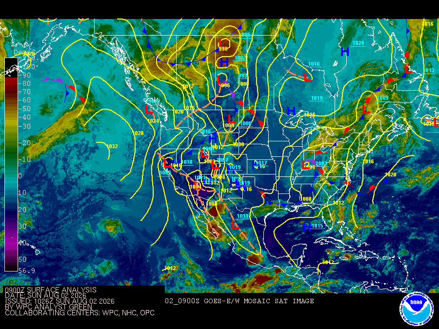
Gulf coastal waters from Bonita Beach to the mouth of the Suwannee River out to 60 NM. Important notice to mariners.marine forecasts are issued at least four times a day. Boaters on extended trips should routinely monitor subsequent forecast issuances and updates for the latest marine weather information. The wave heights are forecast as significant wave height which is the average of the highest one-third of the waves. The highest waves may rarely be twice the significant wave height. The winds and seas near thunderstorms may be higher than forecast. A cold front will be pushing through overnight. This will quickly shift winds to the northwest and start increasing becoming 20 to 25 knots with gust up to 30 knots. These wins will slowly come down Thursday night but still be around 10 to 15 knots on Friday. High pressure to our north will keeping winds northerly around 10 to 15 knots on Saturday before shifting east and calming down to 5 to 10 knots on Sunday. &&

SMALL CRAFT ADVISORY IN EFFECT FROM THURSDAY MORNING THROUGH LATE THURSDAY NIGHT
Reporting time 02:24 PM EST Wed Feb 4 2026
SMALL CRAFT ADVISORY IN EFFECT FROM THURSDAY MORNING THROUGH LATE THURSDAY NIGHT
Reporting time 02:24 PM EST Wed Feb 4 2026
SMALL CRAFT ADVISORY IN EFFECT FROM THURSDAY MORNING THROUGH LATE THURSDAY NIGHT
Reporting time 02:24 PM EST Wed Feb 4 2026
SMALL CRAFT ADVISORY IN EFFECT FROM THURSDAY MORNING THROUGH LATE THURSDAY NIGHT
Reporting time 02:24 PM EST Wed Feb 4 2026
SMALL CRAFT ADVISORY IN EFFECT FROM THURSDAY MORNING THROUGH LATE THURSDAY NIGHT
Reporting time 02:24 PM EST Wed Feb 4 2026
SMALL CRAFT ADVISORY IN EFFECT FROM THURSDAY MORNING THROUGH LATE THURSDAY NIGHT
Reporting time 02:24 PM EST Wed Feb 4 2026
SMALL CRAFT ADVISORY IN EFFECT FROM THURSDAY MORNING THROUGH LATE THURSDAY NIGHT
Reporting time 02:24 PM EST Wed Feb 4 2026
SMALL CRAFT ADVISORY IN EFFECT FROM THURSDAY MORNING THROUGH LATE THURSDAY NIGHT
Reporting time 02:24 PM EST Wed Feb 4 2026
Oilrig
NWS
Buoy
Fixed Station
USGS
Ship
Other