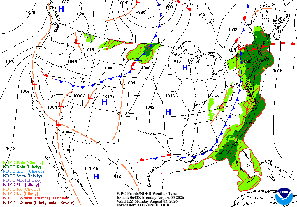
Tall Timbers, MD
02/19/2026 12:00 PM
43°F
TEMPERATURE
Winds 9 mph E
Light Rain Likely
Rain likely before 2pm, then rain and patchy fog. Cloudy, with a high near 44. East wind around 10 mph. Chance of precipitation is 100%. New rainfall amounts between a quarter and half of an inch possible.
Moonrise
07:52 AM
Moonset
08:24 PM
Sunrise
06:50 AM
Moon Phase
Waxing crescent
Sunset
05:49 PM

Hourly Forecast

Thu, 12:00 PM

Light Rain Likely
Winds: 9 mph E
43°

Thu, 01:00 PM

Chance Rain
Winds: 9 mph E
43°

Thu, 02:00 PM

Rain Likely
Winds: 9 mph E
43°

Thu, 03:00 PM

Rain
Winds: 9 mph E
43°

Thu, 04:00 PM

Rain
Winds: 10 mph E
42°

Thu, 05:00 PM

Rain
Winds: 10 mph E
42°

Thu, 06:00 PM

Rain
Winds: 10 mph E
43°

Thu, 07:00 PM

Rain
Winds: 10 mph E
44°

Thu, 08:00 PM

Rain
Winds: 10 mph E
44°

Thu, 09:00 PM

Rain Likely
Winds: 9 mph E
44°

Thu, 10:00 PM

Chance Light Rain
Winds: 9 mph E
44°

Thu, 11:00 PM

Chance Light Rain
Winds: 8 mph E
44°

Fri, 12:00 AM

Patchy Fog
Winds: 8 mph E
44°

Fri, 01:00 AM

Chance Light Rain
Winds: 7 mph E
44°

Fri, 02:00 AM

Chance Light Rain
Winds: 7 mph E
44°

Fri, 03:00 AM

Chance Light Rain
Winds: 6 mph E
44°

Fri, 04:00 AM

Chance Light Rain
Winds: 6 mph E
44°

Fri, 05:00 AM

Light Rain Likely
Winds: 6 mph E
44°

Fri, 06:00 AM

Light Rain
Winds: 6 mph SE
43°

Fri, 07:00 AM

Light Rain
Winds: 6 mph SE
43°

Fri, 08:00 AM

Light Rain
Winds: 6 mph SE
44°

Fri, 09:00 AM

Light Rain
Winds: 6 mph S
45°

Fri, 10:00 AM

Light Rain
Winds: 6 mph SW
46°

Fri, 11:00 AM

Light Rain
Winds: 7 mph SW
46°
Winds: 10 mph E
Rain likely before 2pm, then rain and patchy fog. Cloudy, with a high near 44. East wind around 10 mph. Chance of precipitation is 100%. New rainfall amounts between a quarter and half of an inch possible.
Winds: 6 to 10 mph E
Rain and patchy fog before midnight, then patchy fog and a slight chance of rain between midnight and 1am, then rain likely and patchy fog. Cloudy, with a low around 42. East wind 6 to 10 mph. Chance of precipitation is 100%. New rainfall amounts between a half and three quarters of an inch possible.
Winds: 6 to 12 mph S
Rain and areas of fog. Mostly cloudy, with a high near 52. South wind 6 to 12 mph. Chance of precipitation is 90%. New rainfall amounts between a tenth and quarter of an inch possible.
Winds: 5 to 12 mph W
A chance of rain before 7pm. Partly cloudy, with a low around 42. West wind 5 to 12 mph. Chance of precipitation is 30%. New rainfall amounts less than a tenth of an inch possible.
Winds: 5 mph N
A slight chance of rain after 7am. Partly sunny, with a high near 49. North wind around 5 mph. Chance of precipitation is 20%.
Winds: 2 to 6 mph E
A chance of rain. Partly cloudy, with a low around 37. Chance of precipitation is 30%.
Winds: 7 to 14 mph NE
Rain likely before 1pm, then rain and snow. Mostly cloudy, with a high near 40. Chance of precipitation is 80%.
Winds: 15 to 18 mph N
Rain and snow before 7pm, then rain and snow likely. Mostly cloudy, with a low around 33. Chance of precipitation is 80%.
Winds: 16 to 21 mph NW
A chance of snow. Partly sunny, with a high near 38. Chance of precipitation is 30%.
Winds: 14 to 17 mph NW
A slight chance of snow before 7pm. Partly cloudy, with a low around 30.
Winds: 6 to 16 mph NW
Sunny, with a high near 38.
Winds: 6 mph SW
Mostly clear, with a low around 30.
Winds: 7 to 15 mph S
Partly sunny, with a high near 45.
Winds: 17 mph SW
A chance of rain after 1am. Mostly cloudy, with a low around 41.

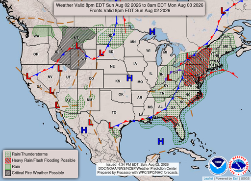
Coastal Waters Forecast

National Weather Service Baltimore MD/Washington DC

FOR THE TIDAL POTOMAC AND MD PORTION OF THE CHESAPEAKE BAY.

Tidal Potomac River and Maryland portion of Chesapeake Bay. Forecasts of wave heights do not include effects of wind direction relative to tidal currents. Expect higher waves when winds are blowing against the tidal flow. Waves flat where waters are iced over. A front will waver near the local waters through Friday, with chances for rain and fog each day. Relatively higher pressure is forecast Saturday before low pressure develops along the coast Sunday. Small Craft Advisories are possible late Friday into Saturday, and likely Sunday into Monday.

DENSE FOG ADVISORY IN EFFECT UNTIL NOON EST TODAY
Reporting time 09:58 AM EST Thu Feb 19 2026
DENSE FOG ADVISORY IN EFFECT UNTIL NOON EST TODAY
Reporting time 09:58 AM EST Thu Feb 19 2026
DENSE FOG ADVISORY IN EFFECT UNTIL NOON EST TODAY
Reporting time 09:58 AM EST Thu Feb 19 2026
DENSE FOG ADVISORY IN EFFECT UNTIL NOON EST TODAY
Reporting time 09:58 AM EST Thu Feb 19 2026
DENSE FOG ADVISORY IN EFFECT UNTIL NOON EST TODAY
Reporting time 09:58 AM EST Thu Feb 19 2026
DENSE FOG ADVISORY IN EFFECT UNTIL NOON EST TODAY
Reporting time 09:58 AM EST Thu Feb 19 2026
DENSE FOG ADVISORY IN EFFECT UNTIL NOON EST TODAY
Reporting time 09:58 AM EST Thu Feb 19 2026
DENSE FOG ADVISORY IN EFFECT UNTIL NOON EST TODAY
Reporting time 09:58 AM EST Thu Feb 19 2026
DENSE FOG ADVISORY IN EFFECT UNTIL NOON EST TODAY
Reporting time 09:58 AM EST Thu Feb 19 2026
DENSE FOG ADVISORY IN EFFECT UNTIL NOON EST TODAY
Reporting time 09:58 AM EST Thu Feb 19 2026
DENSE FOG ADVISORY IN EFFECT UNTIL NOON EST TODAY
Reporting time 09:58 AM EST Thu Feb 19 2026
DENSE FOG ADVISORY IN EFFECT UNTIL NOON EST TODAY
Reporting time 09:58 AM EST Thu Feb 19 2026
DENSE FOG ADVISORY IN EFFECT UNTIL NOON EST TODAY
Reporting time 09:58 AM EST Thu Feb 19 2026
DENSE FOG ADVISORY IN EFFECT UNTIL NOON EST TODAY
Reporting time 09:58 AM EST Thu Feb 19 2026
Oilrig
NWS
Buoy
Fixed Station
USGS
Ship
Other