St. Johns, FL
11/25/2025 04:00 AM
61°F
TEMPERATURE
Winds 2 mph SE
Patchy Fog
Areas of fog. Mostly cloudy, with a low around 60. South wind around 2 mph.
Moonrise
10:48 AM
Moonset
09:00 PM
Sunrise
06:59 AM
Moon Phase
Waxing crescent
Sunset
05:26 PM

Hourly Forecast

Tue, 04:00 AM

Patchy Fog
Winds: 2 mph SE
61°

Tue, 05:00 AM

Areas Of Fog
Winds: 2 mph S
61°

Tue, 06:00 AM

Widespread Fog
Winds: 2 mph S
60°

Tue, 07:00 AM

Areas Of Fog
Winds: 2 mph S
60°

Tue, 08:00 AM

Widespread Fog
Winds: 3 mph S
62°

Tue, 09:00 AM

Mostly Sunny
Winds: 6 mph S
69°

Tue, 10:00 AM

Partly Sunny
Winds: 7 mph S
74°

Tue, 11:00 AM

Mostly Sunny
Winds: 7 mph S
79°

Tue, 12:00 PM

Partly Sunny
Winds: 8 mph S
82°

Tue, 01:00 PM

Partly Sunny
Winds: 8 mph S
83°

Tue, 02:00 PM

Partly Sunny
Winds: 8 mph S
84°

Tue, 03:00 PM

Partly Sunny
Winds: 9 mph S
84°

Tue, 04:00 PM

Partly Sunny
Winds: 8 mph S
83°

Tue, 05:00 PM

Mostly Sunny
Winds: 8 mph SE
79°

Tue, 06:00 PM

Partly Cloudy
Winds: 8 mph SE
75°

Tue, 07:00 PM

Partly Cloudy
Winds: 7 mph SE
72°

Tue, 08:00 PM

Partly Cloudy
Winds: 6 mph S
70°

Tue, 09:00 PM

Partly Cloudy
Winds: 5 mph S
69°

Tue, 10:00 PM

Partly Cloudy
Winds: 5 mph S
68°

Tue, 11:00 PM

Mostly Cloudy
Winds: 5 mph S
67°

Wed, 12:00 AM

Partly Cloudy
Winds: 5 mph S
66°

Wed, 01:00 AM

Partly Cloudy
Winds: 5 mph S
65°

Wed, 02:00 AM

Partly Cloudy
Winds: 5 mph SW
64°

Wed, 03:00 AM

Partly Cloudy
Winds: 5 mph SW
64°
Winds: 2 mph S
Areas of fog. Mostly cloudy, with a low around 60. South wind around 2 mph.
Winds: 2 to 9 mph S
Widespread fog before 9am. Partly sunny. High near 84, with temperatures falling to around 79 in the afternoon. South wind 2 to 9 mph.
Winds: 5 to 8 mph S
Partly cloudy, with a low around 62. South wind 5 to 8 mph.
Winds: 5 to 12 mph SW
Partly sunny, with a high near 84. Southwest wind 5 to 12 mph, with gusts as high as 17 mph.
Winds: 6 to 10 mph NW
Mostly cloudy, with a low around 52. Northwest wind 6 to 10 mph, with gusts as high as 16 mph.
Winds: 10 mph NW
Mostly sunny, with a high near 67.
Winds: 8 to 12 mph NW
Mostly clear, with a low around 41.
Winds: 12 mph N
Sunny, with a high near 60.
Winds: 8 mph N
Partly cloudy, with a low around 44.
Winds: 9 to 14 mph NE
Partly sunny, with a high near 70.
Winds: 8 to 12 mph E
Mostly cloudy, with a low around 58.
Winds: 8 to 12 mph E
A slight chance of rain showers after 1pm. Partly sunny, with a high near 75. Chance of precipitation is 20%.
Winds: 6 to 9 mph E
A slight chance of rain showers. Mostly cloudy, with a low around 62. Chance of precipitation is 20%.
Winds: 6 to 10 mph E
A slight chance of rain showers. Partly sunny, with a high near 79.

Coastal Waters Forecast for Northeast Florida/Southeast Georgia

National Weather Service Jacksonville FL

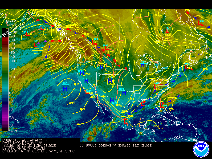
Atlantic Coastal Waters from Altamaha Sound GA to Flagler Beach FL out to 60 nm. Seas are provided as a range of the average height of the highest 1/3 of the waves, along with the occasional height of the average highest 1/10 of the waves. High pressure system will move northeast of the area today resulting in breezy winds veering gradually to the southeast and south by Wednesday. A strong cold front approaches from the west late Wednesday. The front will press south of the local waters Wednesday night into Thursday, trailed by northwest to north winds approaching Small Craft Advisory conditions, which will continue on Friday and possibly into Saturday as winds shift to the northeast and east. .GULF STREAM. The approximate location of the west wall of the Gulf Stream as of Nov 22, 2025 at 1200 UTC. 39 nautical miles east northeast of Flagler Beach. 38 nautical miles east northeast of Saint Augustine Beach. 41 nautical miles east of Jacksonville Beach. 58 nautical miles east southeast of St Simons Island. This data courtesy of the Naval Oceanographic Office.

REST OF TONIGHT
Southeast winds 5 to 10 knots Seas 2 to 3 feet Wave Detail: Northeast 3 feet at 6 seconds Intracoastal waters light chop A slight chance of showers
TUESDAY
South winds 5 to 10 knots Seas 2 to 3 feet Wave Detail: East 3 feet at 6 seconds Intracoastal waters light chop
TUESDAY NIGHT
South winds 10 to 15 knots Seas around 3 feet Wave Detail: East 3 feet at 7 seconds and south 2 feet at 4 seconds Intracoastal waters a moderate chop
WEDNESDAY
Southwest winds around 10 knots Seas 2 to 3 feet Wave Detail: Southeast 3 feet at 5 seconds and east 2 feet at 8 seconds Intracoastal waters light chop
WEDNESDAY NIGHT AND THURSDAY
Northwest winds 15 to 20 knots Seas 2 to 4 feet, occasionally to 5 feet Wave Detail: North 4 feet at 4 seconds and east 2 feet at 7 seconds Intracoastal waters choppy
THURSDAY NIGHT
Northwest winds 20 to 25 knots with gusts up to 35 knots Seas 4 to 6 feet, occasionally to 8 feet Wave Detail: North 5 feet at 5 seconds Intracoastal waters rough
FRIDAY THROUGH SATURDAY
East winds 20 to 25 knots Seas 3 to 5 feet, occasionally to 6 feet Intracoastal waters rough
Reporting time 12:24 AM EST Tue Nov 25 2025
REST OF TONIGHT
Southeast winds 10 to 15 knots Seas 3 to 4 feet, occasionally to 5 feet Wave Detail: East 3 feet at 6 seconds A slight chance of showers late this evening, then a chance of showers with a slight chance of thunderstorms
TUESDAY
South winds around 10 knots Seas 3 to 4 feet, occasionally to 5 feet Wave Detail: East 3 feet at 6 seconds A slight chance of showers in the morning
TUESDAY NIGHT
South winds 10 to 15 knots Seas 3 to 4 feet, occasionally to 5 feet Wave Detail: East 3 feet at 7 seconds and south 2 feet at 3 seconds
WEDNESDAY
Southwest winds 10 to 15 knots Seas 3 to 4 feet, occasionally to 5 feet Wave Detail: East 3 feet at 7 seconds and south 2 feet at 4 seconds
WEDNESDAY NIGHT AND THURSDAY
Northwest winds 15 to 20 knots Seas 3 to 5 feet, occasionally to 6 feet Wave Detail: Northwest 4 feet at 5 seconds and east 2 feet at 8 seconds
THURSDAY NIGHT
Northwest winds 15 to 20 knots, becoming north 20 to 25 knots with gusts up to 35 knots after midnight Seas 4 to 6 feet, occasionally to 8 feet Wave Detail: North 6 feet at 6 seconds and east 2 feet at 8 seconds
FRIDAY
North winds 15 to 20 knots Seas 4 to 6 feet, occasionally to 8 feet, subsiding to 3 to 4 feet, occasionally to 5 feet after midnight
SATURDAY
East winds 15 to 20 knots Seas 4 to 6 feet, occasionally to 8 feet A slight chance of showers after midnight
Reporting time 12:24 AM EST Tue Nov 25 2025
Oilrig
NWS
Buoy
Fixed Station
USGS
Ship
Other