Hourly Forecast
Thu, 05:00 AM
Mostly ClearWinds: 3 mph SW
Thu, 06:00 AM
SunnyWinds: 3 mph SW
Thu, 07:00 AM
SunnyWinds: 2 mph SW
Thu, 08:00 AM
SunnyWinds: 2 mph SW
Thu, 09:00 AM
SunnyWinds: 3 mph S
Thu, 10:00 AM
SunnyWinds: 5 mph SE
Thu, 11:00 AM
SunnyWinds: 6 mph E
Thu, 12:00 PM
SunnyWinds: 7 mph E
Thu, 01:00 PM
SunnyWinds: 9 mph E
Thu, 02:00 PM
SunnyWinds: 10 mph E
Thu, 03:00 PM
SunnyWinds: 12 mph E
Thu, 04:00 PM
SunnyWinds: 12 mph E
Thu, 05:00 PM
SunnyWinds: 12 mph E
Thu, 06:00 PM
Mostly ClearWinds: 12 mph E
Thu, 07:00 PM
Mostly ClearWinds: 10 mph SE
Thu, 08:00 PM
Mostly ClearWinds: 10 mph SE
Thu, 09:00 PM
Mostly ClearWinds: 10 mph SE
Thu, 10:00 PM
Mostly ClearWinds: 9 mph SE
Thu, 11:00 PM
Mostly ClearWinds: 9 mph SE
Fri, 12:00 AM
Mostly ClearWinds: 8 mph S
Fri, 01:00 AM
Mostly ClearWinds: 7 mph S
Fri, 02:00 AM
Mostly ClearWinds: 7 mph S
Fri, 03:00 AM
Mostly ClearWinds: 6 mph S
Fri, 04:00 AM
Mostly ClearWinds: 6 mph S
Coastal Waters Forecast for Northeast Florida/Southeast Georgia
National Weather Service Jacksonville FL
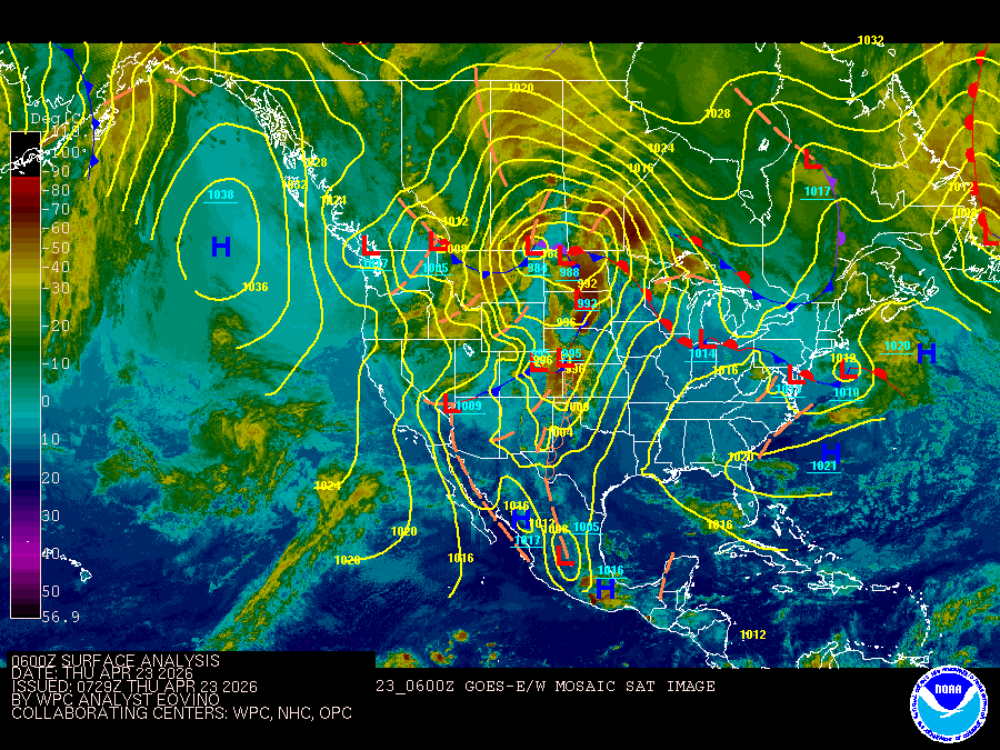
Atlantic Coastal Waters from Altamaha Sound GA to Flagler Beach FL out to 60 nm. Seas are provided as a range of the average height of the highest 1/3 of the waves, along with the occasional height of the average highest 1/10 of the waves. High pressure situated along the southeastern seaboard will gradually weaken and shift southeastward through Friday night. Southeasterly winds will increase across the near shore waters each afternoon through Saturday behind the inland moving Atlantic sea breeze, with winds shifting to southerly during the early evening hours and then southwesterly after midnight. A frontal boundary will sink into the southeastern states by Saturday evening, with isolated showers and thunderstorms possible on Saturday afternoon ahead of this boundary. Widely scattered showers and thunderstorms will be possible on Saturday night and Sunday as this front stalls near the Georgia waters. This front will then lift northward early next week ahead of another front that will approach our local waters towards the middle portion of next week. .GULF STREAM. The approximate location of the west wall of the Gulf Stream as of Apr 22, 2026 at 0000 UTC. 50 nautical miles east of Flagler Beach. 58 nautical miles east of Saint Augustine Beach. 70 nautical miles east southeast of Jacksonville Beach. 76 nautical miles east southeast of St Simons Island. This data derived from NCEP Global RTOFS model.
Search Results
