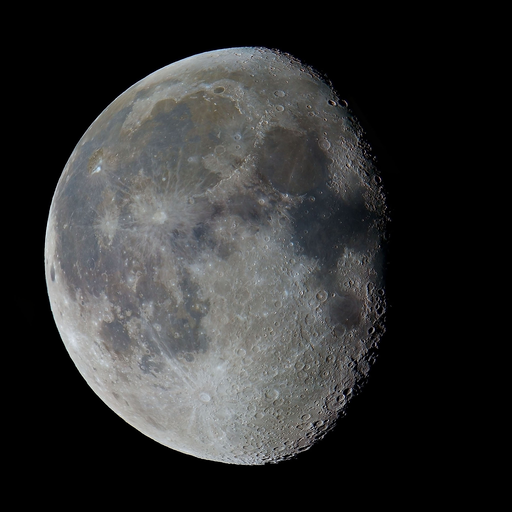
Hourly Forecast
Mon, 03:00 PM
SunnyWinds: 0 mph
Mon, 04:00 PM
SunnyWinds: 0 mph
Mon, 05:00 PM
SunnyWinds: 5 mph SE
Mon, 06:00 PM
ClearWinds: 5 mph SSE
Mon, 07:00 PM
ClearWinds: 5 mph SSE
Mon, 08:00 PM
ClearWinds: 0 mph
Mon, 09:00 PM
ClearWinds: 0 mph
Mon, 10:00 PM
ClearWinds: 0 mph
Mon, 11:00 PM
ClearWinds: 0 mph
Tue, 12:00 AM
ClearWinds: 0 mph
Tue, 01:00 AM
ClearWinds: 0 mph
Tue, 02:00 AM
ClearWinds: 0 mph
Tue, 03:00 AM
ClearWinds: 0 mph
Tue, 04:00 AM
ClearWinds: 0 mph
Tue, 05:00 AM
ClearWinds: 0 mph
Tue, 06:00 AM
SunnyWinds: 5 mph S
Tue, 07:00 AM
SunnyWinds: 5 mph S
Tue, 08:00 AM
SunnyWinds: 5 mph S
Tue, 09:00 AM
SunnyWinds: 5 mph SSW
Tue, 10:00 AM
SunnyWinds: 5 mph SW
Tue, 11:00 AM
SunnyWinds: 10 mph SW
Tue, 12:00 PM
SunnyWinds: 10 mph SW
Tue, 01:00 PM
SunnyWinds: 10 mph SSW
Tue, 02:00 PM
SunnyWinds: 10 mph SSW
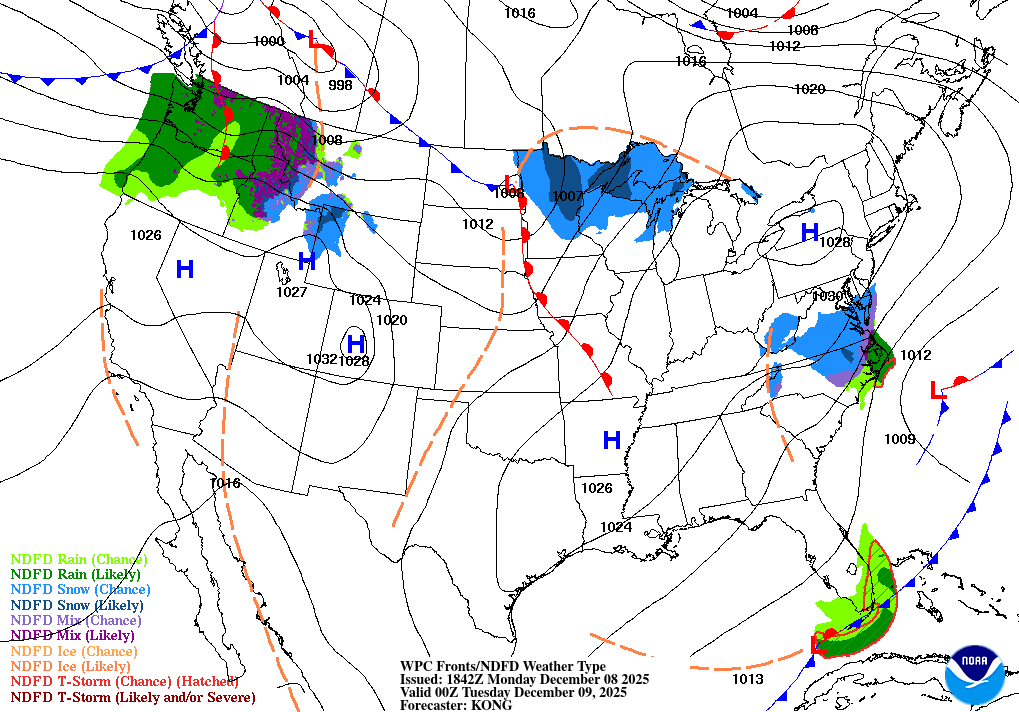
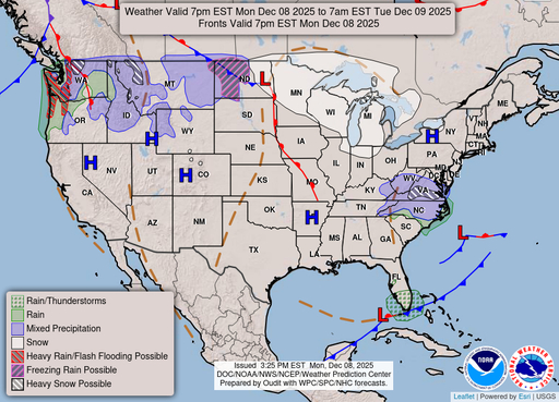
Coastal Waters Forecast for Texas
National Weather Service Houston/Galveston TX
For High Island to the Matagorda Ship Channel Out 60 NM including Galveston and Matagorda Bays.
Upper Texas coastal waters from High Island to the Matagorda Ship Channel out 60 nautical miles including Galveston and Matagorda Bays. Seas are provided as a range of the average height of the highest 1/3 of the waves.along with the occasional height of the average highest 10 percent of the waves. Winds and seas continue to gradually subside following Sunday's cold front, but small craft should continue to exercise caution through this afternoon in the offshore Gulf waters due to lingering elevated winds and seas. Northeasterly winds continue into early Tuesday, then onshore flow returns by Tuesday afternoon. There may be a window of opportunity for patchy sea fog Tuesday night. A cold front could push offshore late in the week bringing gusty winds and building seas, but quite a bit of uncertainty remains in this part of the forecast.
Search Results
