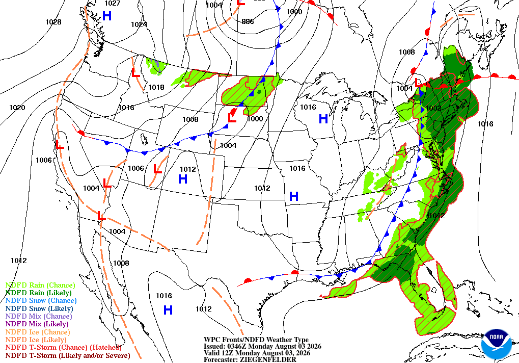
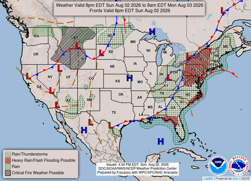
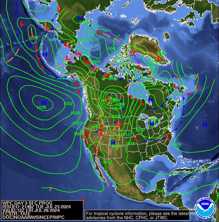
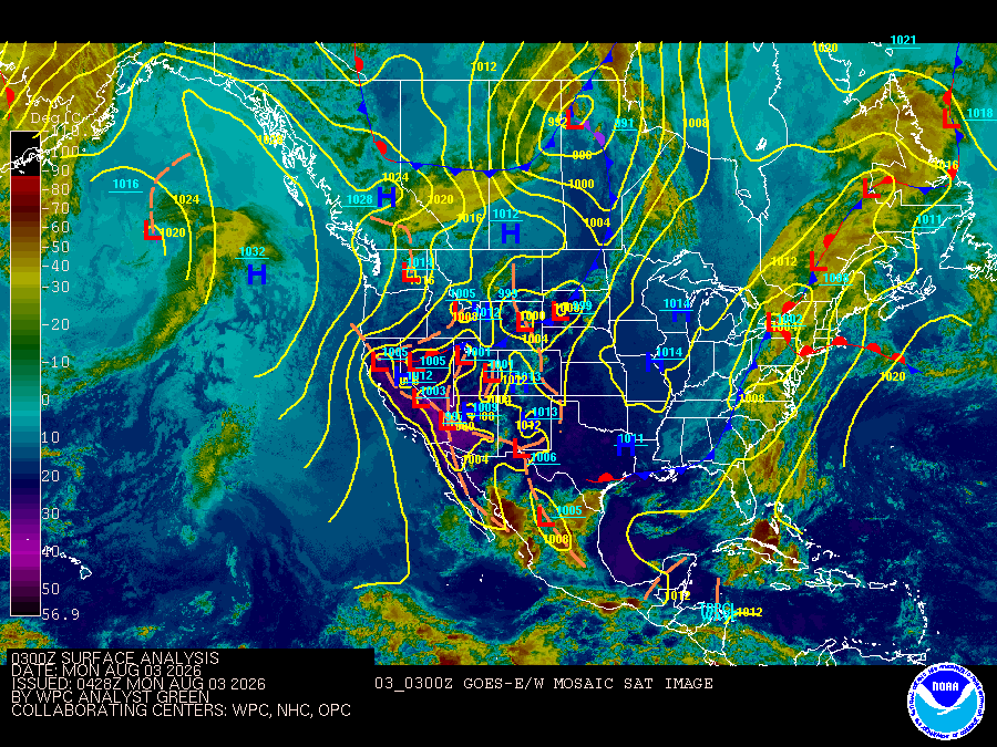
Lake Worth, FL
05/05/2026 03:00 AM
73°F
TEMPERATURE
Winds 6 mph E
Slight Chance Showers And Thunderstorms
A chance of showers and thunderstorms. Mostly cloudy, with a low around 71. East wind around 6 mph. Chance of precipitation is 30%.
Moonrise
11:58 PM
Moonset
09:24 AM
Sunrise
06:39 AM
Moon Phase
Waning gibbous
Sunset
07:54 PM

Hourly Forecast

Tue, 03:00 AM

Slight Chance Showers And Thunderstorms
Winds: 6 mph E
73°

Tue, 04:00 AM

Slight Chance Showers And Thunderstorms
Winds: 6 mph E
73°

Tue, 05:00 AM

Chance Showers And Thunderstorms
Winds: 6 mph E
73°

Tue, 06:00 AM

Chance Showers And Thunderstorms
Winds: 6 mph E
72°

Tue, 07:00 AM

Chance Showers And Thunderstorms
Winds: 6 mph E
73°

Tue, 08:00 AM

Chance Showers And Thunderstorms
Winds: 6 mph E
73°

Tue, 09:00 AM

Slight Chance Showers And Thunderstorms
Winds: 6 mph E
75°

Tue, 10:00 AM

Slight Chance Showers And Thunderstorms
Winds: 6 mph E
78°

Tue, 11:00 AM

Slight Chance Showers And Thunderstorms
Winds: 7 mph E
79°

Tue, 12:00 PM

Partly Sunny
Winds: 8 mph E
80°

Tue, 01:00 PM

Mostly Sunny
Winds: 9 mph E
79°

Tue, 02:00 PM

Mostly Sunny
Winds: 9 mph E
80°

Tue, 03:00 PM

Mostly Sunny
Winds: 9 mph E
80°

Tue, 04:00 PM

Mostly Sunny
Winds: 9 mph E
81°

Tue, 05:00 PM

Mostly Sunny
Winds: 9 mph E
81°

Tue, 06:00 PM

Partly Cloudy
Winds: 8 mph E
80°

Tue, 07:00 PM

Partly Cloudy
Winds: 7 mph E
79°

Tue, 08:00 PM

Partly Cloudy
Winds: 6 mph E
78°

Tue, 09:00 PM

Mostly Clear
Winds: 6 mph E
77°

Tue, 10:00 PM

Partly Cloudy
Winds: 6 mph E
76°

Tue, 11:00 PM

Partly Cloudy
Winds: 5 mph E
76°

Wed, 12:00 AM

Mostly Clear
Winds: 5 mph E
75°

Wed, 01:00 AM

Mostly Clear
Winds: 3 mph E
75°

Wed, 02:00 AM

Partly Cloudy
Winds: 3 mph E
74°
Winds: 6 mph E
A chance of showers and thunderstorms. Mostly cloudy, with a low around 71. East wind around 6 mph. Chance of precipitation is 30%.
Winds: 6 to 9 mph E
A chance of showers and thunderstorms before 8am, then a chance of showers and thunderstorms between 8am and 9am, then a slight chance of showers and thunderstorms between 9am and noon. Mostly sunny, with a high near 82. East wind 6 to 9 mph. Chance of precipitation is 40%. New rainfall amounts less than a tenth of an inch possible.
Winds: 3 to 8 mph E
Partly cloudy, with a low around 72. East wind 3 to 8 mph.
Winds: 2 to 9 mph SE
Mostly sunny, with a high near 85. Southeast wind 2 to 9 mph.
Winds: 3 to 8 mph SE
Mostly clear, with a low around 72. Southeast wind 3 to 8 mph.
Winds: 2 to 9 mph S
Sunny, with a high near 88. South wind 2 to 9 mph.
Winds: 3 to 9 mph S
Partly cloudy, with a low around 73. South wind 3 to 9 mph.
Winds: 3 to 9 mph SW
Mostly sunny, with a high near 89. Southwest wind 3 to 9 mph.
Winds: 3 to 9 mph S
Partly cloudy, with a low around 75. South wind 3 to 9 mph.
Winds: 3 to 10 mph S
A chance of showers and thunderstorms after 2pm. Mostly sunny, with a high near 90. Chance of precipitation is 30%.
Winds: 2 to 9 mph S
A chance of showers and thunderstorms before 8pm. Mostly cloudy, with a low around 75. Chance of precipitation is 30%.
Winds: 2 to 10 mph S
A slight chance of rain showers between 8am and 2pm, then a chance of showers and thunderstorms. Partly sunny, with a high near 88. Chance of precipitation is 30%.
Winds: 3 to 9 mph SE
A chance of showers and thunderstorms. Mostly cloudy, with a low around 76. Chance of precipitation is 30%.
Winds: 3 to 10 mph SE
A slight chance of showers and thunderstorms before 8am, then a chance of showers and thunderstorms between 8am and 2pm, then a chance of showers and thunderstorms. Partly sunny, with a high near 88.

Coastal Waters Forecast for Florida

National Weather Service Miami FL

for Jupiter Inlet to Ocean Reef FL out to 60 nm and for East Cape Sable to Bonita Beach FL out to 60 nm.

Atlantic coastal waters from Jupiter Inlet to Ocean Reef out to 60 nm and Gulf coastal waters from East Cape Sable to Chokoloskee out 20 nm and Chokoloskee to Bonita Beach out 60 nm.including the waters of Biscayne Bay and Lake Okeechobee. Seas are provided as a range of the average height of the highest 1/3 of the waves.along with the occasional height of the average highest 10 percent of the waves. Northeasterly winds continue at all coastal waters as a stationary frontal boundary remains to our south over the Florida Straits. Breezy periods with gusty winds are possible, in over the northern Atlantic waters. A Small Craft Advisory is in effect for the northern Atlantic waters through 8pm this evening. Any showers and thunderstorms that develop across local waters today may result in locally elevated hazardous wave and winds. Winds will gradually lessen and veer more easterly in direction on Tuesday. Gulf Stream Hazards: Gusty winds around 20 knots with higher gusts possible and waves of 6 to 7 feet across the northern Atlantic waters. The approximate location of the west wall of the Gulf Stream as of Apr 29, 2026. 8 nautical miles north northeast of Fowey Rocks. 7 nautical miles east of Port Everglades. 10 nautical miles east southeast of Lake Worth. 11 nautical miles east northeast of Jupiter Inlet. This data courtesy of the Naval Oceanographic Office.

SMALL CRAFT ADVISORY IN EFFECT UNTIL 8 PM EDT THIS EVENING
Reporting time 04:02 PM EDT Mon May 4 2026
TONIGHT
E winds 10 to 15 kt, diminishing to 5 to 10 kt after midnight Seas 3 to 5 ft, occasionally to 6 ft Wave Detail: N 4 ft at 7 seconds Intracoastal waters a moderate chop A chance of showers and tstms
TUE
SE winds 5 to 10 kt Seas 2 to 4 ft, occasionally to 5 ft Wave Detail: N 3 ft at 6 seconds Intracoastal waters light chop A chance of showers in the morning
TUE NIGHT
SE winds 5 to 10 kt Seas around 2 ft Wave Detail: N 2 ft at 6 seconds and E 1 foot at 2 seconds Intracoastal waters light chop
WED
SE winds around 5 kt Seas around 2 ft Wave Detail: SE 1 foot at 2 seconds and N 1 foot at 5 seconds Intracoastal waters smooth
WED NIGHT THROUGH THU NIGHT
S winds 5 to 10 kt Seas less than 2 ft or less Wave Detail: E 1 foot at 2 seconds and N 1 foot at 5 seconds Intracoastal waters light chop
FRI THROUGH SAT
S winds 5 to 10 kt Seas 1 to 2 ft Wave Detail: S 1 foot at 3 seconds Intracoastal waters light chop
SAT NIGHT
SE winds 5 to 10 kt Seas around 2 ft Intracoastal waters light chop
Reporting time 04:02 PM EDT Mon May 4 2026
TONIGHT
NE winds 5 to 10 kt Seas around 2 ft Wave Detail: N 2 ft at 5 seconds Bay and inland waters light chop A chance of showers with a slight chance of tstms this evening, then a slight chance of showers after midnight
TUE
NE winds 5 to 10 kt, becoming W in the afternoon Seas less than 2 ft or less Wave Detail: NE 1 foot at 2 seconds and NW 1 foot at 4 seconds Bay and inland waters light chop
TUE NIGHT
NW winds around 5 kt, becoming NE after midnight Seas less than 2 ft or less Wave Detail: NW 1 foot at 4 seconds Bay and inland waters smooth
WED
SE winds around 5 kt, becoming S in the afternoon Seas less than 2 ft or less Bay and inland waters smooth
WED NIGHT
S winds around 5 kt Seas less than 2 ft or less Bay and inland waters smooth
THU AND THU NIGHT
SW winds 5 to 10 kt Seas less than 2 ft or less Wave Detail: S 1 foot at 2 seconds and SW 1 foot at 5 seconds Bay and inland waters light chop
FRI THROUGH SAT
E winds 5 to 10 kt Seas less than 2 ft or less Bay and inland waters light chop
Reporting time 04:02 PM EDT Mon May 4 2026
SMALL CRAFT SHOULD EXERCISE CAUTION
Reporting time 04:02 PM EDT Mon May 4 2026
TONIGHT
E winds 5 to 10 kt Light chop Showers likely with a chance of tstms this evening, then a chance of showers with a slight chance of tstms after midnight
TUE
NE winds around 5 kt, becoming SE in the afternoon Light chop
TUE NIGHT
SE winds 5 to 10 kt Light chop
WED
S winds around 5 kt, becoming SE in the afternoon Light chop
WED NIGHT THROUGH THU NIGHT
SW winds 5 to 10 kt Light chop
FRI THROUGH SAT
SE winds 5 to 10 kt Light chop
Reporting time 04:02 PM EDT Mon May 4 2026
Oilrig
NWS
Buoy
Fixed Station
USGS
Ship
Other