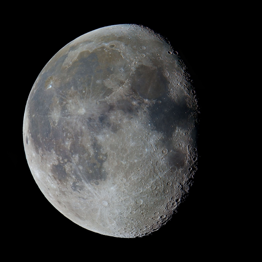
Lake Oakland, MI
12/01/2025 01:00 AM
19°F
TEMPERATURE
Winds 6 mph WNW
Mostly Clear
Mostly clear. Low around 11, with temperatures rising to around 15 overnight. West northwest wind around 6 mph.
Moonrise
02:08 PM
Moonset
02:17 AM
Sunrise
07:43 AM
Moon Phase
Waxing gibbous
Sunset
05:01 PM

Hourly Forecast

Mon, 01:00 AM

Mostly Clear
Winds: 6 mph WNW
19°

Mon, 02:00 AM

Mostly Clear
Winds: 5 mph WNW
18°

Mon, 03:00 AM

Mostly Clear
Winds: 5 mph WNW
16°

Mon, 04:00 AM

Mostly Clear
Winds: 5 mph WNW
16°

Mon, 05:00 AM

Mostly Clear
Winds: 3 mph WNW
15°

Mon, 06:00 AM

Sunny
Winds: 3 mph WNW
14°

Mon, 07:00 AM

Sunny
Winds: 3 mph W
14°

Mon, 08:00 AM

Mostly Sunny
Winds: 3 mph W
15°

Mon, 09:00 AM

Mostly Sunny
Winds: 2 mph W
19°

Mon, 10:00 AM

Partly Sunny
Winds: 3 mph WSW
22°

Mon, 11:00 AM

Partly Sunny
Winds: 3 mph SW
25°

Mon, 12:00 PM

Partly Sunny
Winds: 5 mph SW
26°

Mon, 01:00 PM

Mostly Cloudy
Winds: 6 mph SW
28°

Mon, 02:00 PM

Mostly Cloudy
Winds: 6 mph SSW
28°

Mon, 03:00 PM

Mostly Cloudy
Winds: 6 mph SSW
29°

Mon, 04:00 PM

Cloudy
Winds: 5 mph SSW
28°

Mon, 05:00 PM

Cloudy
Winds: 5 mph S
26°

Mon, 06:00 PM

Cloudy
Winds: 5 mph S
24°

Mon, 07:00 PM

Light Snow
Winds: 2 mph S
25°

Mon, 08:00 PM

Light Snow
Winds: 2 mph SSE
24°

Mon, 09:00 PM

Light Snow
Winds: 2 mph SSE
23°

Mon, 10:00 PM

Light Snow
Winds: 2 mph S
23°

Mon, 11:00 PM

Light Snow
Winds: 1 mph S
23°

Tue, 12:00 AM

Light Snow
Winds: 1 mph SSE
22°
Winds: 6 mph WNW
Mostly clear. Low around 11, with temperatures rising to around 15 overnight. West northwest wind around 6 mph.
Winds: 2 to 6 mph WSW
Partly sunny. High near 29, with temperatures falling to around 26 in the afternoon. West southwest wind 2 to 6 mph.
Winds: 1 to 5 mph S
Snow after 7pm. Cloudy, with a low around 19. South wind 1 to 5 mph. Chance of precipitation is 80%. New snow accumulation of around one inch possible.
Winds: 1 to 6 mph WNW
Snow likely before 7am. Partly sunny, with a high near 30. West northwest wind 1 to 6 mph. Chance of precipitation is 70%. New snow accumulation of less than one inch possible.
Winds: 2 to 7 mph WSW
Mostly cloudy, with a low around 17. West southwest wind 2 to 7 mph.
Winds: 7 to 12 mph SW
Cloudy, with a high near 31.
Winds: 9 mph W
A chance of snow after 7pm. Mostly cloudy, with a low around 14.
Winds: 7 to 10 mph WNW
A slight chance of snow before 7am. Partly sunny, with a high near 21.
Winds: 6 mph WSW
Partly cloudy, with a low around 7.
Winds: 6 to 9 mph SSW
A slight chance of snow after 1pm. Partly sunny, with a high near 23.
Winds: 6 mph SW
A chance of snow. Mostly cloudy, with a low around 16.
Winds: 5 to 8 mph W
A chance of snow. Mostly cloudy, with a high near 30.
Winds: 6 mph WSW
A chance of snow. Mostly cloudy, with a low around 19.
Winds: 7 mph NW
A chance of snow. Mostly cloudy, with a high near 29.

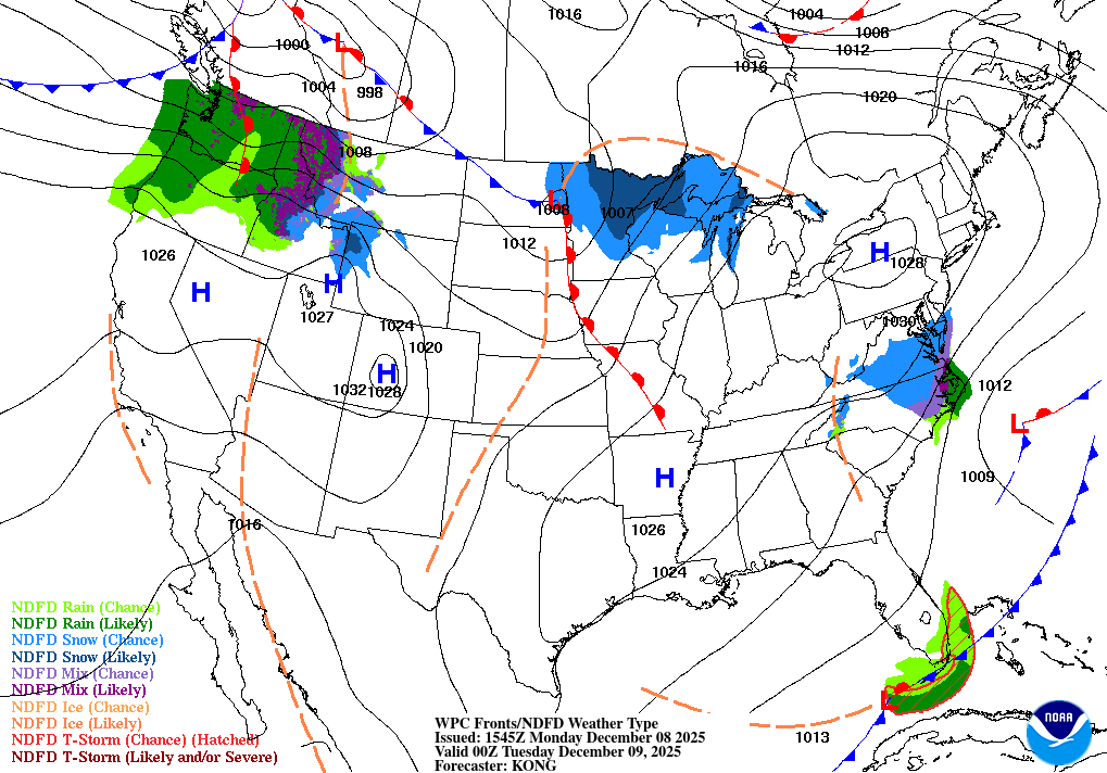
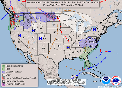
Nearshore Marine Forecast for Michigan

National Weather Service Detroit/Pontiac MI

For waters within five nautical miles of shore Waves are the significant wave height - the average of the highest 1/3 of the wave spectrum. Occasional wave height is the average of the highest 1/10 of the wave spectrum. REST OF TONIGHT.Northwest winds 15 to 20 knots diminishing to 10 to 15 knots early in the morning. Mostly clear. Waves 1 to 3 feet. .MONDAY.West winds 5 to 10 knots becoming southwest 10 to 15 knots in the late morning and afternoon. Partly cloudy until late afternoon becoming mostly cloudy. Waves 2 feet or less. .MONDAY NIGHT.South winds 15 to 20 knots becoming southwest 10 to 15 knots after midnight. Cloudy. Light snow likely until early morning. Waves 1 to 3 feet. .TUESDAY.West winds 10 to 15 knots. Partly cloudy. Waves 2 feet or less. See Lake Huron Open Lake Forecast for days 3 through 5.

SMALL CRAFT ADVISORY IN EFFECT UNTIL 7 AM EST MONDAY
Reporting time 10:03 PM EST Sun Nov 30 2025
SMALL CRAFT ADVISORY IN EFFECT UNTIL 7 AM EST MONDAY
Reporting time 10:03 PM EST Sun Nov 30 2025
SMALL CRAFT ADVISORY IN EFFECT UNTIL 7 AM EST MONDAY
Reporting time 10:03 PM EST Sun Nov 30 2025
SMALL CRAFT ADVISORY IN EFFECT UNTIL 7 AM EST MONDAY
Reporting time 10:03 PM EST Sun Nov 30 2025
REST OF TONIGHT
Northwest winds 15 to 20 knots diminishing to 10 to 15 knots after midnight Mostly clear Waves 2 feet or less
MONDAY
Northwest winds 5 to 10 knots early in the morning becoming light and variable Mostly sunny becoming partly cloudy in the late morning and early afternoon becoming mostly cloudy Waves 2 feet or less
MONDAY NIGHT
Southeast winds 5 to 10 knots veering to the west after midnight Light snow Waves 2 feet or less
TUESDAY
Northwest winds 5 to 10 knots Mostly cloudy early in the morning becoming partly cloudy Waves 2 feet or less
Reporting time 10:03 PM EST Sun Nov 30 2025
Reporting time
Oilrig
NWS
Buoy
Fixed Station
USGS
Ship
Other