Jensen Beach, FL
04/19/2026 10:00 PM
76°F
TEMPERATURE
Winds 5 mph SSE
Mostly Cloudy
A slight chance of showers and thunderstorms between 11pm and 3am, then a chance of showers and thunderstorms. Mostly cloudy, with a low around 69. East northeast wind 0 to 10 mph. Chance of precipitation is 30%. New rainfall amounts between a quarter and half of an inch possible.
Moonrise
09:15 AM
Moonset
11:43 PM
Sunrise
06:51 AM
Moon Phase
Waxing crescent
Sunset
07:48 PM

Hourly Forecast

Sun, 10:00 PM

Mostly Cloudy
Winds: 5 mph SSE
76°

Sun, 11:00 PM

Slight Chance Showers And Thunderstorms
Winds: 5 mph SSE
75°

Mon, 12:00 AM

Slight Chance Showers And Thunderstorms
Winds: 0 mph
75°

Mon, 01:00 AM

Mostly Cloudy
Winds: 0 mph
74°

Mon, 02:00 AM

Slight Chance Showers And Thunderstorms
Winds: 0 mph
73°

Mon, 03:00 AM

Chance Showers And Thunderstorms
Winds: 5 mph ENE
73°

Mon, 04:00 AM

Chance Showers And Thunderstorms
Winds: 5 mph NE
71°

Mon, 05:00 AM

Chance Showers And Thunderstorms
Winds: 10 mph NNE
71°

Mon, 06:00 AM

Chance Showers And Thunderstorms
Winds: 10 mph NNE
71°

Mon, 07:00 AM

Slight Chance Showers And Thunderstorms
Winds: 15 mph NNE
70°

Mon, 08:00 AM

Chance Showers And Thunderstorms
Winds: 15 mph NE
71°

Mon, 09:00 AM

Chance Showers And Thunderstorms
Winds: 15 mph NE
73°

Mon, 10:00 AM

Chance Showers And Thunderstorms
Winds: 15 mph NE
75°

Mon, 11:00 AM

Chance Showers And Thunderstorms
Winds: 15 mph NE
76°

Mon, 12:00 PM

Chance Showers And Thunderstorms
Winds: 15 mph NE
76°

Mon, 01:00 PM

Chance Showers And Thunderstorms
Winds: 15 mph NE
76°

Mon, 02:00 PM

Chance Showers And Thunderstorms
Winds: 15 mph NE
76°

Mon, 03:00 PM

Chance Showers And Thunderstorms
Winds: 15 mph NE
77°

Mon, 04:00 PM

Chance Showers And Thunderstorms
Winds: 15 mph NE
76°

Mon, 05:00 PM

Chance Showers And Thunderstorms
Winds: 20 mph NE
75°

Mon, 06:00 PM

Slight Chance Showers And Thunderstorms
Winds: 20 mph NE
74°

Mon, 07:00 PM

Mostly Cloudy
Winds: 20 mph NE
73°

Mon, 08:00 PM

Mostly Cloudy
Winds: 20 mph NE
72°

Mon, 09:00 PM

Mostly Cloudy
Winds: 20 mph NE
72°
Winds: 0 to 10 mph ENE
A slight chance of showers and thunderstorms between 11pm and 3am, then a chance of showers and thunderstorms. Mostly cloudy, with a low around 69. East northeast wind 0 to 10 mph. Chance of precipitation is 30%. New rainfall amounts between a quarter and half of an inch possible.
Winds: 10 to 20 mph NE
A chance of showers and thunderstorms before 7am, then a slight chance of showers and thunderstorms between 7am and 8am, then a chance of showers and thunderstorms between 8am and 11am, then a chance of showers and thunderstorms between 11am and 5pm, then a chance of showers and thunderstorms. Mostly cloudy, with a high near 78. Northeast wind 10 to 20 mph, with gusts as high as 30 mph. Chance of precipitation is 50%. New rainfall amounts between a half and three quarters of an inch possible.
Winds: 15 to 20 mph NE
A slight chance of showers and thunderstorms before 7pm. Mostly cloudy, with a low around 66. Northeast wind 15 to 20 mph, with gusts as high as 30 mph. Chance of precipitation is 20%. New rainfall amounts between a tenth and quarter of an inch possible.
Winds: 15 mph NE
Sunny, with a high near 77. Northeast wind around 15 mph, with gusts as high as 25 mph.
Winds: 10 to 15 mph ENE
Partly cloudy, with a low around 66. East northeast wind 10 to 15 mph, with gusts as high as 25 mph.
Winds: 10 to 15 mph E
Partly sunny, with a high near 76. East wind 10 to 15 mph, with gusts as high as 20 mph.
Winds: 5 to 10 mph E
Mostly cloudy, with a low around 65. East wind 5 to 10 mph, with gusts as high as 20 mph.
Winds: 5 to 10 mph ESE
Partly sunny, with a high near 77. East southeast wind 5 to 10 mph.
Winds: 5 to 10 mph ESE
Partly cloudy, with a low around 66. East southeast wind 5 to 10 mph.
Winds: 5 to 10 mph ESE
Mostly sunny, with a high near 79. East southeast wind 5 to 10 mph, with gusts as high as 20 mph.
Winds: 5 to 10 mph SE
Partly cloudy, with a low around 66. Southeast wind 5 to 10 mph, with gusts as high as 20 mph.
Winds: 5 to 10 mph SE
Mostly sunny, with a high near 81. Southeast wind 5 to 10 mph.
Winds: 5 to 10 mph SSE
Partly cloudy, with a low around 67. South southeast wind 5 to 10 mph.
Winds: 5 to 10 mph S
A slight chance of showers and thunderstorms after 2pm. Mostly sunny, with a high near 84. South wind 5 to 10 mph.

Coastal Waters Forecast for East Central Florida

National Weather Service Melbourne FL
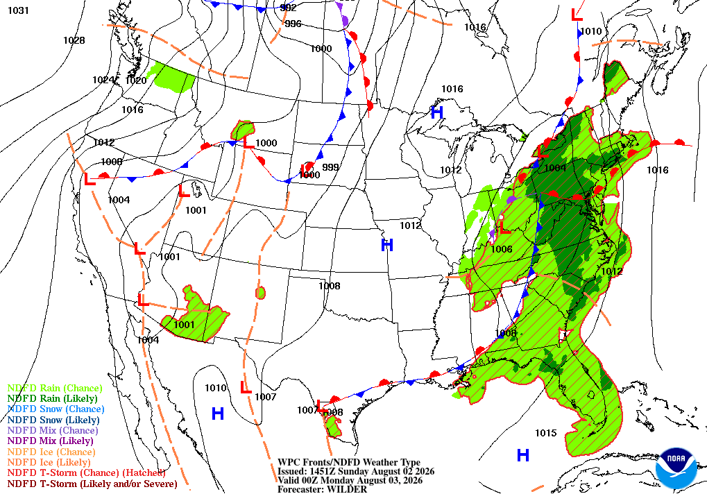
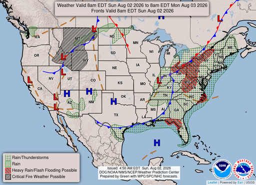
A cold front arrives tonight into Monday, bringing gusty winds, building seas, and additional chances for rain. Poor to hazardous conditions are forecast to linger through at least Tuesday, before improving mid to late week, as high pressure builds over the area.

Atlantic coastal waters from Flagler Beach to Jupiter Inlet out 60 nm. Seas are provided as a range of the average height of the highest one third of the waves, along with the occasional height of the average highest ten percent of the waves. GULF STREAM HAZARDS.Northeast winds increasing to 20 to 25 knots north of Sebastian Inlet. The approximate location of the west wall of the Gulf Stream based on the Real Time Ocean Forecast System as of Sunday, April 19th, 2026. 44 nautical miles east of Ponce Inlet. 30 nautical miles east of Port Canaveral. 24 nautical miles east of Sebastian Inlet. 17 nautical miles east of Fort Pierce Inlet. 9 nautical miles east of Saint Lucie Inlet.

SMALL CRAFT ADVISORY IN EFFECT THROUGH LATE MONDAY NIGHT
Reporting time 08:57 PM EDT Sun Apr 19 2026
SMALL CRAFT SHOULD EXERCISE CAUTION
SMALL CRAFT ADVISORY IN EFFECT FROM 4 AM EDT MONDAY THROUGH TUESDAY AFTERNOON
Reporting time 08:57 PM EDT Sun Apr 19 2026
SMALL CRAFT SHOULD EXERCISE CAUTION LATE TONIGHT
SMALL CRAFT ADVISORY IN EFFECT FROM 8 AM EDT MONDAY THROUGH LATE TUESDAY NIGHT
Reporting time 08:57 PM EDT Sun Apr 19 2026
SMALL CRAFT ADVISORY IN EFFECT THROUGH TUESDAY MORNING
Reporting time 08:57 PM EDT Sun Apr 19 2026
SMALL CRAFT SHOULD EXERCISE CAUTION
SMALL CRAFT ADVISORY IN EFFECT FROM 4 AM EDT MONDAY THROUGH TUESDAY EVENING
Reporting time 08:57 PM EDT Sun Apr 19 2026
SMALL CRAFT ADVISORY IN EFFECT FROM 8 AM EDT MONDAY THROUGH LATE TUESDAY NIGHT
Reporting time 08:57 PM EDT Sun Apr 19 2026
Oilrig
NWS
Buoy
Fixed Station
USGS
Ship
Other