Cape Ann's Marina,
MA
08/03/2026 12:00 PM
74°F
TEMPERATURE
Winds 16 mph S
Chance Rain Showers
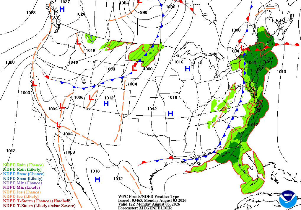
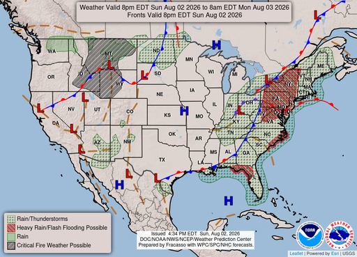
Rain showers likely and patchy fog before 3pm, then patchy fog and a slight chance of rain showers between 3pm and 4pm, then a chance of rain showers and patchy fog. Mostly cloudy, with a high near 76. South wind around 16 mph, with gusts as high as 31 mph. Chance of precipitation is 70%. New rainfall amounts between a quarter and half of an inch possible.

Moonrise
11:08 PM
Moonset
11:49 AM
Sunrise
05:36 AM
Moon Phase
Waning gibbous
Sunset
08:01 PM
Hourly Forecast
Mon, 12:00 PM
Chance Rain ShowersWinds: 16 mph S
74°
Mon, 01:00 PM
Chance Rain ShowersWinds: 16 mph S
74°
Mon, 02:00 PM
Rain Showers LikelyWinds: 16 mph S
75°
Mon, 03:00 PM
Patchy FogWinds: 16 mph S
75°
Mon, 04:00 PM
Chance Rain ShowersWinds: 15 mph S
74°
Mon, 05:00 PM
Chance Rain ShowersWinds: 14 mph S
74°
Mon, 06:00 PM
Chance Rain ShowersWinds: 14 mph S
74°
Mon, 07:00 PM
Rain Showers LikelyWinds: 13 mph SW
72°
Mon, 08:00 PM
Chance Rain ShowersWinds: 12 mph SW
72°
Mon, 09:00 PM
Slight Chance Rain ShowersWinds: 10 mph SW
71°
Mon, 10:00 PM
Mostly CloudyWinds: 9 mph SW
70°
Mon, 11:00 PM
Partly CloudyWinds: 8 mph W
69°
Tue, 12:00 AM
Partly CloudyWinds: 8 mph W
69°
Tue, 01:00 AM
Partly CloudyWinds: 8 mph W
68°
Tue, 02:00 AM
Partly CloudyWinds: 7 mph W
67°
Tue, 03:00 AM
Mostly ClearWinds: 7 mph W
67°
Tue, 04:00 AM
Mostly ClearWinds: 7 mph W
66°
Tue, 05:00 AM
Mostly ClearWinds: 7 mph W
66°
Tue, 06:00 AM
SunnyWinds: 7 mph W
65°
Tue, 07:00 AM
SunnyWinds: 6 mph W
66°
Tue, 08:00 AM
SunnyWinds: 6 mph W
67°
Tue, 09:00 AM
SunnyWinds: 7 mph W
68°
Tue, 10:00 AM
SunnyWinds: 7 mph W
71°
Tue, 11:00 AM
SunnyWinds: 7 mph W
72°
Winds: 16 mph S
Rain showers likely and patchy fog before 3pm, then patchy fog and a slight chance of rain showers between 3pm and 4pm, then a chance of rain showers and patchy fog. Mostly cloudy, with a high near 76. South wind around 16 mph, with gusts as high as 31 mph. Chance of precipitation is 70%. New rainfall amounts between a quarter and half of an inch possible.
Winds: 7 to 14 mph SW
Rain showers likely and patchy fog before 10pm. Partly cloudy, with a low around 65. Southwest wind 7 to 14 mph, with gusts as high as 24 mph. Chance of precipitation is 60%. New rainfall amounts between a tenth and quarter of an inch possible.
Winds: 7 mph SW
Sunny, with a high near 78. Southwest wind around 7 mph.
Winds: 6 mph SW
Partly cloudy, with a low around 65. Southwest wind around 6 mph.
Winds: 2 to 7 mph S
Mostly sunny, with a high near 77. South wind 2 to 7 mph.
Winds: 6 mph SW
Partly cloudy, with a low around 67. Southwest wind around 6 mph.
Winds: 5 to 8 mph S
A slight chance of rain showers after 5pm. Mostly sunny, with a high near 81. South wind 5 to 8 mph.
Winds: 7 mph SW
Partly cloudy, with a low around 72. Southwest wind around 7 mph.
Winds: 7 mph SW
A slight chance of showers and thunderstorms after 4pm. Mostly sunny, with a high near 90. Southwest wind around 7 mph.
Winds: 6 mph SW
A slight chance of showers and thunderstorms before 1am. Partly cloudy, with a low around 72. Southwest wind around 6 mph.
Winds: 6 mph SW
A slight chance of showers and thunderstorms after 2pm. Mostly sunny, with a high near 87. Southwest wind around 6 mph.
Winds: 5 mph SW
A slight chance of showers and thunderstorms before 1am. Partly cloudy, with a low around 70. Southwest wind around 5 mph.
Winds: 3 to 7 mph SW
Mostly sunny, with a high near 88. Southwest wind 3 to 7 mph.
Winds: 7 mph SW
Partly cloudy, with a low around 70. Southwest wind around 7 mph.
Coastal Waters Forecast for Massachusetts and Rhode Island
National Weather Service Boston/Norton MA
for Massachusetts and Rhode Island coastal waters. SCA conditions to start the week as low pressure brings heavy rain and gusty wind through Monday night. Seas build to between 5 and 7 feet across the outer waters and winds increase to between 15 and 20 kt. Chance for isolated gale conditions across Buzzards Bay and Nantucket sound Monday afternoon. A few weak disturbances arrive next week but impacts to boaters should be minimal.
Coastal waters from the Merrimack River MA to Watch Hill RI out to 60 NM
SMALL CRAFT ADVISORY IN EFFECT THROUGH TUESDAY AFTERNOON
SMALL CRAFT ADVISORY IN EFFECT UNTIL 5 PM EDT THIS AFTERNOON
SMALL CRAFT ADVISORY IN EFFECT UNTIL 5 PM EDT THIS AFTERNOON
SMALL CRAFT ADVISORY IN EFFECT THROUGH TUESDAY AFTERNOON
SMALL CRAFT ADVISORY IN EFFECT THROUGH TUESDAY EVENING
SMALL CRAFT ADVISORY IN EFFECT THROUGH TUESDAY EVENING
SMALL CRAFT ADVISORY IN EFFECT THROUGH LATE TONIGHT
SMALL CRAFT ADVISORY IN EFFECT THROUGH LATE TONIGHT
SMALL CRAFT ADVISORY IN EFFECT THROUGH LATE TONIGHT
SMALL CRAFT ADVISORY IN EFFECT THROUGH TUESDAY AFTERNOON
SMALL CRAFT ADVISORY IN EFFECT THROUGH TUESDAY AFTERNOON
SMALL CRAFT ADVISORY IN EFFECT UNTIL 5 PM EDT THIS AFTERNOON
SMALL CRAFT ADVISORY IN EFFECT UNTIL 5 PM EDT THIS AFTERNOON
THIS AFTERNOON
S winds 20 to 25 kt with gusts up to 30 kt Seas 5 to 7 ft Wave Detail: S 7 ft at 8 seconds and E 1 foot at 8 seconds Patchy fog A slight chance of showers A chance of showers
TONIGHT
SW winds 20 to 25 kt, becoming W 15 to 20 kt after midnight Gusts up to 30 kt Seas 5 to 7 ft Wave Detail: SW 7 ft at 8 seconds and SE 4 ft at 8 seconds Showers likely, mainly in the evening Patchy fog in the evening with vsby 1 NM or less
TUE
W winds 10 to 15 kt Gusts up to 25 kt in the morning Seas 3 to 5 ft Wave Detail: W 5 ft at 7 seconds and SE 2 ft at 9 seconds
TUE NIGHT
SW winds 5 to 10 kt Seas 2 to 4 ft Wave Detail: SW 4 ft at 7 seconds and SE 2 ft at 10 seconds
WED AND WED NIGHT
SW winds 5 to 10 kt Seas 2 to 3 ft Wave Detail: S 3 ft at 7 seconds and E 1 foot at 11 seconds
THU THROUGH FRI NIGHT
SW winds 10 to 15 kt with gusts up to 25 kt Seas 2 to 3 ft Wave Detail: SW 3 ft at 6 seconds and E 1 foot at 9 seconds
THIS AFTERNOON
S winds 20 to 25 kt with gusts up to 30 kt Seas 5 to 7 ft, building to 6 to 9 ft Wave Detail: S 7 ft at 8 seconds and E 1 foot at 8 seconds, becoming S 8 ft at 8 seconds and E 1 foot at 8 seconds Patchy fog A chance of showers
TONIGHT
SW winds 20 to 25 kt, becoming W 15 to 20 kt after midnight Gusts up to 30 kt Seas 7 to 9 ft, subsiding to 5 to 8 ft after midnight Wave Detail: S 8 ft at 8 seconds and E 1 foot at 8 seconds, becoming SW 8 ft at 8 seconds and E 1 foot at 8 seconds A chance of showers Patchy fog in the evening with vsby 1 NM or less
TUE
W winds 10 to 15 kt with gusts up to 20 kt, becoming SW 5 to 10 kt in the afternoon Seas 5 to 7 ft, subsiding to 4 to 5 ft in the afternoon Wave Detail: SW 6 ft at 8 seconds and E 1 foot at 9 seconds, becoming SW 5 ft at 8 seconds and E 1 foot at 9 seconds
TUE NIGHT
SW winds 5 to 10 kt Seas 3 to 4 ft Wave Detail: S 4 ft at 7 seconds and E 1 foot at 11 seconds
WED AND WED NIGHT
SW winds 5 to 10 kt Seas 3 to 4 ft Wave Detail: S 4 ft at 7 seconds and E 1 foot at 10 seconds
THU THROUGH FRI NIGHT
SW winds 10 to 15 kt with gusts up to 25 kt Seas 3 to 4 ft Wave Detail: S 4 ft at 7 seconds and E 1 foot at 9 seconds
THIS AFTERNOON
S winds 20 to 25 kt with gusts up to 30 kt Seas 8 to 10 ft Wave Detail: S 9 ft at 8 seconds and E 1 foot at 9 seconds Patchy fog Showers likely with isolated tstms
TONIGHT
SW winds 20 to 25 kt, becoming W 15 to 20 kt after midnight Gusts up to 30 kt Seas 8 to 10 ft, subsiding to 6 to 9 ft after midnight Wave Detail: SW 9 ft at 8 seconds and E 1 foot at 8 seconds, becoming SW 8 ft at 8 seconds Showers Patchy fog in the evening with vsby 1 to 3 NM
TUE
NW winds 5 to 10 kt, becoming W in the afternoon Seas 5 to 7 ft, subsiding to 4 to 5 ft in the afternoon Wave Detail: S 6 ft at 8 seconds and E 1 foot at 12 seconds, becoming S 5 ft at 8 seconds and E 1 foot at 9 seconds
TUE NIGHT
S winds around 5 kt Seas 3 to 4 ft Wave Detail: S 4 ft at 7 seconds and E 1 foot at 9 seconds
WED
S winds 5 to 10 kt Seas around 3 ft Wave Detail: S 3 ft at 7 seconds and E 1 foot at 10 seconds A chance of showers in the morning
WED NIGHT
SW winds 5 to 10 kt Seas 3 to 5 ft Wave Detail: S 5 ft at 7 seconds and E 1 foot at 10 seconds
THU THROUGH FRI NIGHT
SW winds 10 to 15 kt with gusts up to 20 kt Seas 4 to 5 ft
THIS AFTERNOON
S winds 20 to 25 kt with gusts up to 30 kt Seas 8 to 9 ft, building to 9 to 11 ft Wave Detail: S 9 ft at 8 seconds and E 1 foot at 9 seconds, becoming E 11 ft at 9 seconds and S 10 ft at 9 seconds Patchy fog Isolated tstms A slight chance of showers, then a chance of showers
TONIGHT
SW winds 20 to 25 kt, becoming W 15 to 20 kt after midnight Gusts up to 30 kt Seas 8 to 10 ft, subsiding to 6 to 8 ft after midnight Wave Detail: S 9 ft at 8 seconds and NE 1 foot at 9 seconds, becoming S 8 ft at 8 seconds and E 1 foot at 7 seconds Showers likely, mainly in the evening Patchy fog in the evening with vsby 1 to 3 NM
TUE
N winds around 10 kt, becoming E in the afternoon Seas 4 to 6 ft Wave Detail: S 6 ft at 8 seconds and NE 1 foot at 10 seconds
TUE NIGHT
S winds around 5 kt Seas 3 to 4 ft Wave Detail: S 4 ft at 7 seconds and SE 2 ft at 11 seconds
WED
S winds 5 to 10 kt Seas 3 to 4 ft Wave Detail: S 4 ft at 7 seconds and E 1 foot at 10 seconds A chance of showers in the morning
WED NIGHT
SW winds around 10 kt Seas 4 to 5 ft Wave Detail: S 5 ft at 7 seconds and E 1 foot at 10 seconds
THU THROUGH FRI NIGHT
SW winds 10 to 15 kt with gusts up to 25 kt Seas 4 to 5 ft
Oilrig
NWS
Buoy
Fixed Station
USGS
Ship
Other
Search Results
