All Public Waters in Virginia,
VA
12/08/2025 10:00 AM
38°F
TEMPERATURE
Winds 14 mph NE
Chance Light Rain
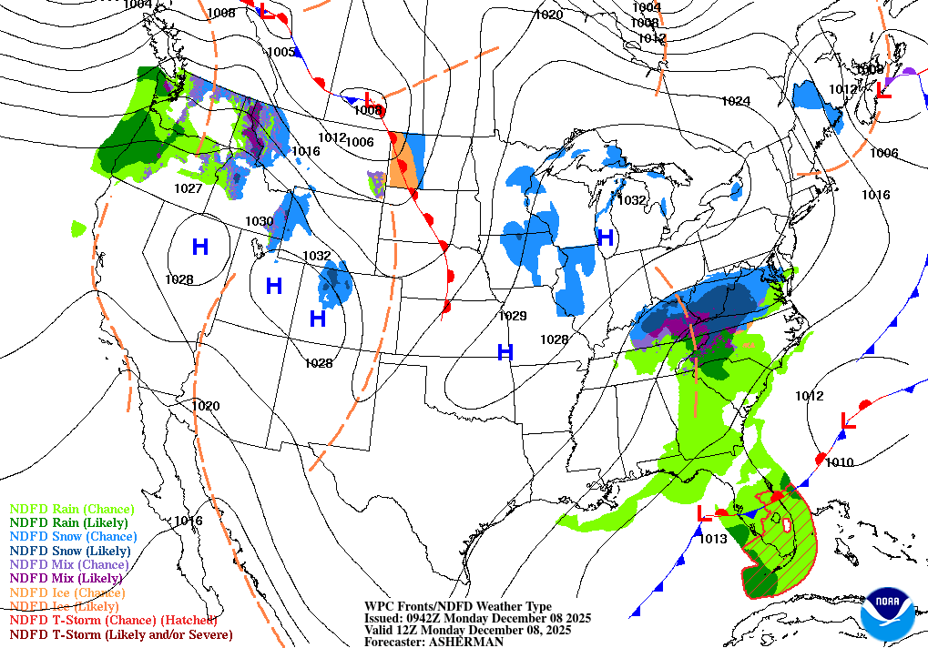
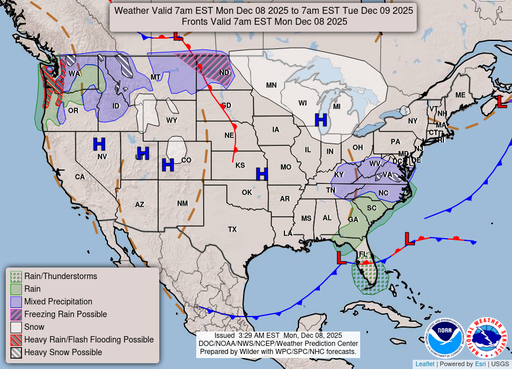
Rain before 1pm, then rain and snow. Cloudy, with a high near 39. Northeast wind 14 to 18 mph, with gusts as high as 30 mph. Chance of precipitation is 90%. New snow accumulation of less than one inch possible.
Alerts
You have (1) alert(s). Tap to see details.
| Winter Weather Advisory issued December 8 at 10:13AM EST until December 9 at 12:00AM EST by NWS Wakefield VA | ||
| NWS Wakefield VA | ||
| Category | Certainty | Severity |
| Met | Likely | Moderate |
| Status | Urgency | Category |
| Actual | Expected | Met |
| Effective | Ends | Expires |
| 12/08/2025 10:13 AM | 12/09/2025 12:00 AM | 12/08/2025 06:15 PM |
* WHAT...Snow expected. Total snow accumulations 1 to 3  inches.
Winds gusting as high as 40 mph.

* WHERE...Portions of northeast North Carolina and eastern and
southeast Virginia.

* WHEN...From 2 PM this afternoon to midnight EST tonight.

* IMPACTS...Plan on slippery road conditions. The hazardous
conditions could impact the Monday evening commute.

* ADDITIONAL DETAILS...Rain changes to snow later in the afternoon,
and may become heavy at times this evening, especially inland from
the coast.
|
||
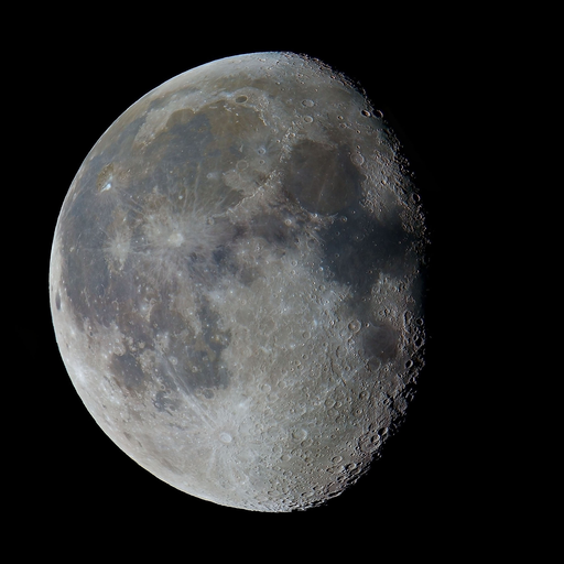
Moonrise
09:02 PM
Moonset
10:46 AM
Sunrise
07:05 AM
Moon Phase
Waning gibbous
Sunset
04:49 PM
Hourly Forecast
Mon, 10:00 AM
Chance Light RainWinds: 14 mph NE
38°
Mon, 11:00 AM
Light RainWinds: 15 mph N
37°
Mon, 12:00 PM
Light RainWinds: 17 mph N
37°
Mon, 01:00 PM
Rain And SnowWinds: 18 mph N
36°
Mon, 02:00 PM
Rain And SnowWinds: 18 mph N
35°
Mon, 03:00 PM
Rain And SnowWinds: 18 mph N
35°
Mon, 04:00 PM
Rain And SnowWinds: 18 mph N
34°
Mon, 05:00 PM
Rain And Snow LikelyWinds: 18 mph N
34°
Mon, 06:00 PM
Snow LikelyWinds: 16 mph N
33°
Mon, 07:00 PM
Chance Rain And SnowWinds: 15 mph N
32°
Mon, 08:00 PM
Chance Rain And SnowWinds: 14 mph N
32°
Mon, 09:00 PM
Chance Rain And SnowWinds: 13 mph N
32°
Mon, 10:00 PM
Chance Rain And SnowWinds: 13 mph N
32°
Mon, 11:00 PM
Slight Chance Light SnowWinds: 12 mph N
32°
Tue, 12:00 AM
Slight Chance Light SnowWinds: 10 mph N
32°
Tue, 01:00 AM
Mostly CloudyWinds: 10 mph N
32°
Tue, 02:00 AM
Mostly CloudyWinds: 9 mph N
32°
Tue, 03:00 AM
Partly CloudyWinds: 8 mph N
31°
Tue, 04:00 AM
Partly CloudyWinds: 8 mph N
31°
Tue, 05:00 AM
Partly CloudyWinds: 7 mph N
30°
Tue, 06:00 AM
Mostly SunnyWinds: 7 mph N
29°
Tue, 07:00 AM
SunnyWinds: 6 mph N
30°
Tue, 08:00 AM
SunnyWinds: 6 mph N
31°
Tue, 09:00 AM
SunnyWinds: 7 mph N
33°
Winds: 14 to 18 mph NE
Rain before 1pm, then rain and snow. Cloudy, with a high near 39. Northeast wind 14 to 18 mph, with gusts as high as 30 mph. Chance of precipitation is 90%. New snow accumulation of less than one inch possible.
Winds: 7 to 16 mph N
Snow likely before 7pm, then a chance of rain and snow between 7pm and 1am. Mostly cloudy, with a low around 27. North wind 7 to 16 mph, with gusts as high as 26 mph. Chance of precipitation is 60%. New snow accumulation of less than one inch possible.
Winds: 3 to 7 mph NW
Sunny, with a high near 42. Northwest wind 3 to 7 mph.
Winds: 2 to 8 mph SW
Partly cloudy, with a low around 29. Southwest wind 2 to 8 mph.
Winds: 9 to 15 mph SW
Partly sunny, with a high near 53. Southwest wind 9 to 15 mph, with gusts as high as 24 mph.
Winds: 8 to 13 mph SW
Mostly cloudy, with a low around 37.
Winds: 6 to 9 mph NW
Mostly sunny, with a high near 48.
Winds: 6 mph W
Mostly cloudy, with a low around 31.
Winds: 5 to 8 mph W
Partly sunny, with a high near 48.
Winds: 5 to 9 mph W
A slight chance of rain and snow after 1am. Mostly cloudy, with a low around 29.
Winds: 9 to 14 mph W
A slight chance of rain and snow before 7am. Sunny, with a high near 43.
Winds: 10 mph NW
Mostly clear, with a low around 23.
Winds: 7 to 10 mph NW
Mostly sunny, with a high near 37.
Winds: 6 mph NW
Mostly clear, with a low around 22.
Coastal Waters Forecast for Virginia
National Weather Service Wakefield VA
for Fenwick Island DE to Currituck Beach Light NC out 20 nautical miles including Virginia portion of the Chesapeake Bay, Currituck Sound and portions of the James, York, and Rappahannock Rivers.
Virginia Portion of the Chesapeake Bay, Currituck Sound and Atlantic Coastal Waters from Fenwick Island DE to Currituck Beach Light NC out 20 nautical miles Degraded marine conditions will continue into tonight in the wake of strong cold front that dropped across the area this morning. Rain/snow mix will also be possible across the waters today. Another system will bring windy marine conditions mid week through late week.
SMALL CRAFT ADVISORY IN EFFECT THROUGH LATE TONIGHT
SMALL CRAFT ADVISORY IN EFFECT THROUGH LATE TONIGHT
SMALL CRAFT ADVISORY IN EFFECT THROUGH LATE TONIGHT
GALE WARNING IN EFFECT THROUGH THIS EVENING
SMALL CRAFT ADVISORY IN EFFECT THROUGH LATE TONIGHT
SMALL CRAFT ADVISORY IN EFFECT THROUGH LATE TONIGHT
GALE WARNING IN EFFECT THROUGH THIS EVENING
GALE WARNING IN EFFECT THROUGH THIS EVENING
GALE WARNING IN EFFECT THROUGH THIS EVENING
GALE WARNING IN EFFECT THROUGH THIS EVENING
SMALL CRAFT ADVISORY IN EFFECT THROUGH THIS EVENING
SMALL CRAFT ADVISORY IN EFFECT THROUGH THIS EVENING
SMALL CRAFT ADVISORY IN EFFECT THROUGH THIS EVENING
SMALL CRAFT ADVISORY IN EFFECT THROUGH THIS EVENING
Oilrig
NWS
Buoy
Fixed Station
USGS
Ship
Other
Search Results
